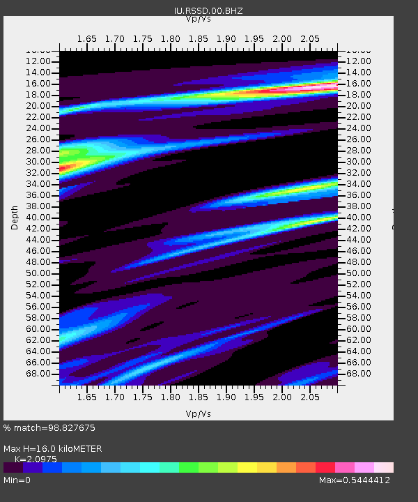
RSSD Black Hills, South Dakota, USA - Earthquake Result Viewer
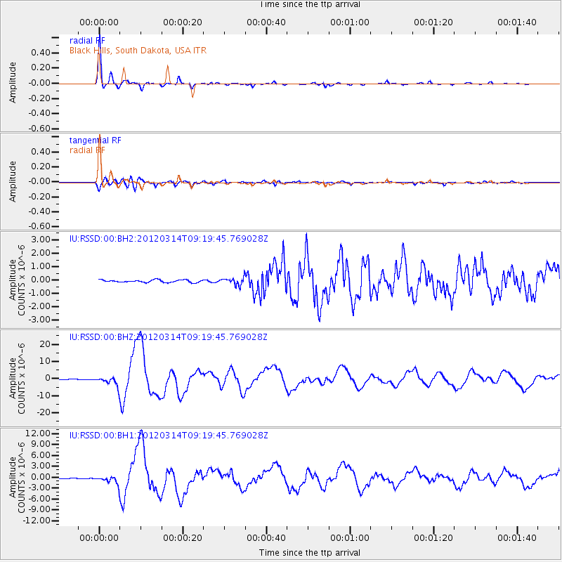
Earthquake location: Off East Coast Of Honshu, Japan
Earthquake latitude/longitude: 40.9/144.9
Earthquake time(UTC): 2012/03/14 (074) 09:08:35 GMT
Earthquake Depth: 12 km
Earthquake Magnitude: 6.7 MB, 6.9 MS, 6.9 MW, 7.0 MW
Earthquake Catalog/Contributor: WHDF/NEIC
Network: IU Global Seismograph Network (GSN - IRIS/USGS)
Station: RSSD Black Hills, South Dakota, USA
Lat/Lon: 44.12 N/104.04 W
Elevation: 2090 m
Distance: 75.1 deg
Az: 44.071 deg
Baz: 312.927 deg
Ray Param: 0.051864766
Estimated Moho Depth: 16.0 km
Estimated Crust Vp/Vs: 2.10
Assumed Crust Vp: 6.242 km/s
Estimated Crust Vs: 2.976 km/s
Estimated Crust Poisson's Ratio: 0.35
Radial Match: 98.827675 %
Radial Bump: 227
Transverse Match: 90.634415 %
Transverse Bump: 400
SOD ConfigId: 558545
Insert Time: 2013-09-19 13:40:36.669 +0000
GWidth: 2.5
Max Bumps: 400
Tol: 0.001

Signal To Noise

ChannelStoNSTALTA
IU:RSSD:00:BHZ:20120314T09:19:45.769028Z19.9791722.9759778E-61.48954E-7
IU:RSSD:00:BH1:20120314T09:19:45.769028Z13.8309221.1963573E-68.6498744E-8
IU:RSSD:00:BH2:20120314T09:19:45.769028Z3.0968462.792354E-79.0167674E-8
Arrivals
Ps2.9 SECOND
PpPs7.7 SECOND
PsPs/PpSs11 SECOND