You are here: Home > Network List > US - United States National Seismic Network Stations List
> Station AMTX Amarillo, Texas, USA > Earthquake Result Viewer
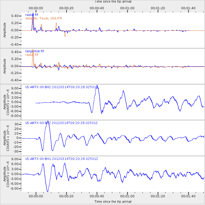
AMTX Amarillo, Texas, USA - Earthquake Result Viewer
*The percent match for this event was below the threshold and hence no stack was calculated.
| Earthquake location: |
Off East Coast Of Honshu, Japan |
| Earthquake latitude/longitude: |
40.9/144.9 |
| Earthquake time(UTC): |
2012/03/14 (074) 09:08:35 GMT |
| Earthquake Depth: |
12 km |
| Earthquake Magnitude: |
6.7 MB, 6.9 MS, 6.9 MW, 7.0 MW |
| Earthquake Catalog/Contributor: |
WHDF/NEIC |
|
| Network: |
US United States National Seismic Network |
| Station: |
AMTX Amarillo, Texas, USA |
| Lat/Lon: |
34.53 N/101.41 W |
| Elevation: |
1010 m |
|
| Distance: |
83.3 deg |
| Az: |
49.596 deg |
| Baz: |
315.629 deg |
| Ray Param: |
$rayparam |
*The percent match for this event was below the threshold and hence was not used in the summary stack. |
|
| Radial Match: |
98.32014 % |
| Radial Bump: |
233 |
| Transverse Match: |
92.80139 % |
| Transverse Bump: |
400 |
| SOD ConfigId: |
558545 |
| Insert Time: |
2013-09-19 13:41:14.033 +0000 |
| GWidth: |
2.5 |
| Max Bumps: |
400 |
| Tol: |
0.001 |
|
Signal To Noise
| Channel | StoN | STA | LTA |
| US:AMTX:00:BHZ:20120314T09:20:28.02501Z | 109.93416 | 1.1551946E-5 | 1.0508059E-7 |
| US:AMTX:00:BH1:20120314T09:20:28.02501Z | 20.360897 | 2.4799715E-6 | 1.218007E-7 |
| US:AMTX:00:BH2:20120314T09:20:28.02501Z | 10.339023 | 2.7231051E-6 | 2.6338128E-7 |
| Arrivals |
| Ps | |
| PpPs | |
| PsPs/PpSs | |


