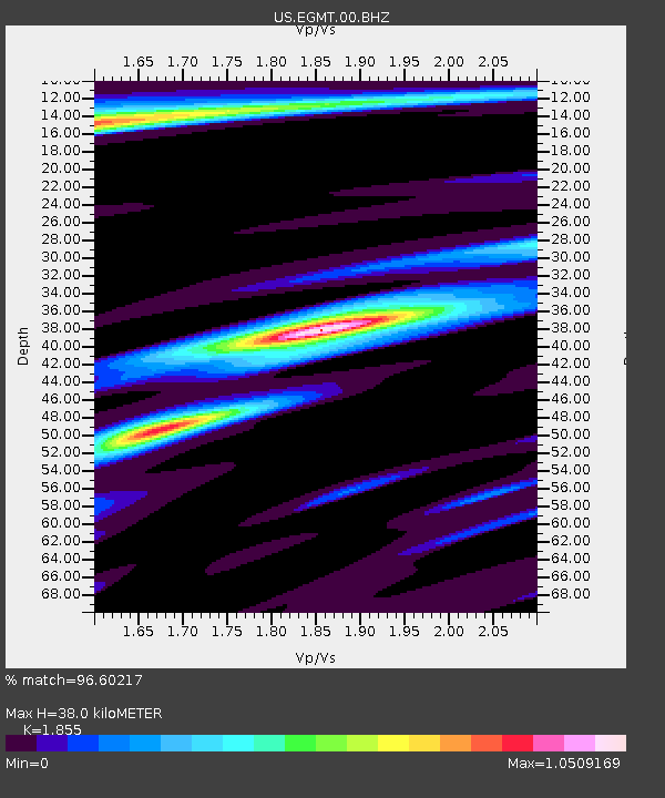
EGMT Eagleton, Montana, USA - Earthquake Result Viewer
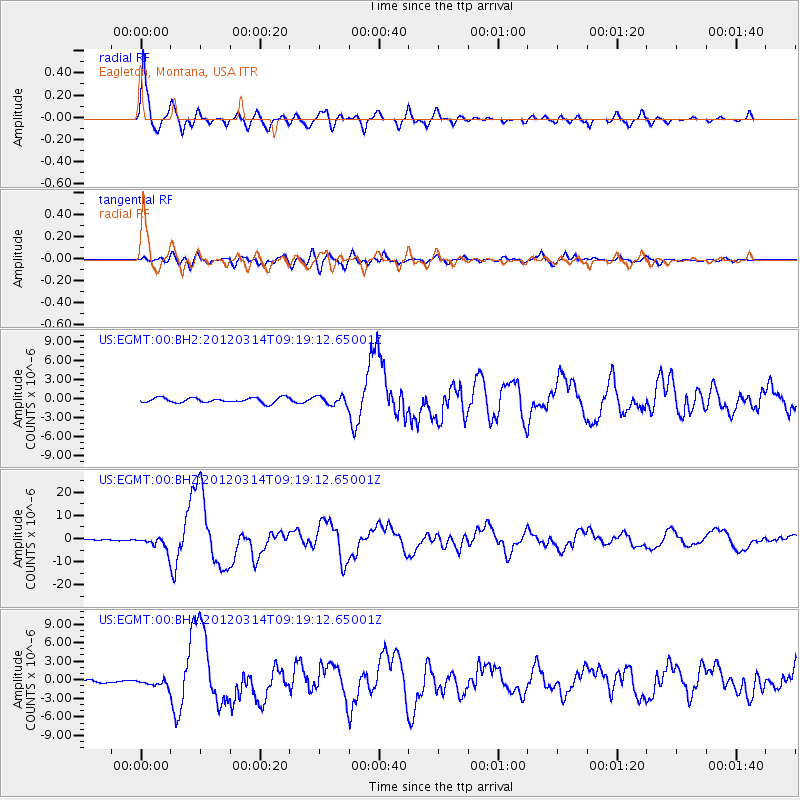
Earthquake location: Off East Coast Of Honshu, Japan
Earthquake latitude/longitude: 40.9/144.9
Earthquake time(UTC): 2012/03/14 (074) 09:08:35 GMT
Earthquake Depth: 12 km
Earthquake Magnitude: 6.7 MB, 6.9 MS, 6.9 MW, 7.0 MW
Earthquake Catalog/Contributor: WHDF/NEIC
Network: US United States National Seismic Network
Station: EGMT Eagleton, Montana, USA
Lat/Lon: 48.02 N/109.75 W
Elevation: 1055 m
Distance: 69.6 deg
Az: 43.705 deg
Baz: 308.707 deg
Ray Param: 0.055552583
Estimated Moho Depth: 38.0 km
Estimated Crust Vp/Vs: 1.86
Assumed Crust Vp: 6.438 km/s
Estimated Crust Vs: 3.47 km/s
Estimated Crust Poisson's Ratio: 0.30
Radial Match: 96.60217 %
Radial Bump: 400
Transverse Match: 75.334564 %
Transverse Bump: 400
SOD ConfigId: 558545
Insert Time: 2013-09-19 13:41:48.529 +0000
GWidth: 2.5
Max Bumps: 400
Tol: 0.001

Signal To Noise

ChannelStoNSTALTA
US:EGMT:00:BHZ:20120314T09:19:12.65001Z11.5211752.8187915E-62.446618E-7
US:EGMT:00:BH1:20120314T09:19:12.65001Z3.25606046.3577784E-71.9525984E-7
US:EGMT:00:BH2:20120314T09:19:12.65001Z1.7749496.999589E-73.9435434E-7
Arrivals
Ps5.2 SECOND
PpPs16 SECOND
PsPs/PpSs21 SECOND