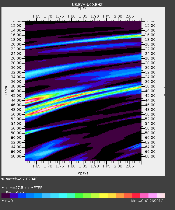
EYMN Ely, Minnesota, USA - Earthquake Result Viewer
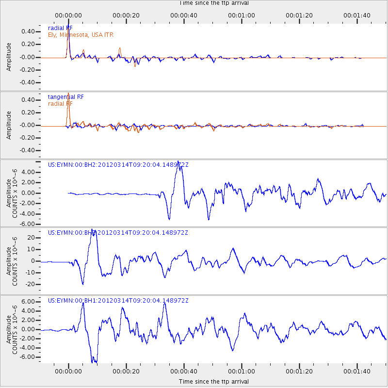
Earthquake location: Off East Coast Of Honshu, Japan
Earthquake latitude/longitude: 40.9/144.9
Earthquake time(UTC): 2012/03/14 (074) 09:08:35 GMT
Earthquake Depth: 12 km
Earthquake Magnitude: 6.7 MB, 6.9 MS, 6.9 MW, 7.0 MW
Earthquake Catalog/Contributor: WHDF/NEIC
Network: US United States National Seismic Network
Station: EYMN Ely, Minnesota, USA
Lat/Lon: 47.95 N/91.50 W
Elevation: 475 m
Distance: 78.4 deg
Az: 34.882 deg
Baz: 319.839 deg
Ray Param: 0.049657032
Estimated Moho Depth: 47.5 km
Estimated Crust Vp/Vs: 1.69
Assumed Crust Vp: 6.467 km/s
Estimated Crust Vs: 3.821 km/s
Estimated Crust Poisson's Ratio: 0.23
Radial Match: 97.87348 %
Radial Bump: 310
Transverse Match: 87.13941 %
Transverse Bump: 400
SOD ConfigId: 558545
Insert Time: 2013-09-19 13:41:53.755 +0000
GWidth: 2.5
Max Bumps: 400
Tol: 0.001

Signal To Noise

ChannelStoNSTALTA
US:EYMN:00:BHZ:20120314T09:20:04.148972Z74.901985.615044E-67.496522E-8
US:EYMN:00:BH1:20120314T09:20:04.148972Z13.5793831.6576878E-61.2207387E-7
US:EYMN:00:BH2:20120314T09:20:04.148972Z16.6979061.4569849E-68.725554E-8
Arrivals
Ps5.2 SECOND
PpPs19 SECOND
PsPs/PpSs24 SECOND