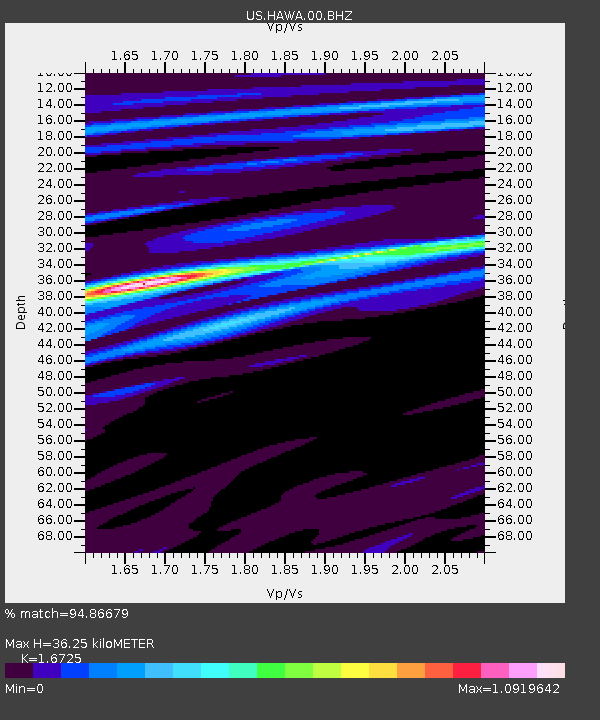
HAWA Hanford, Washington, USA - Earthquake Result Viewer
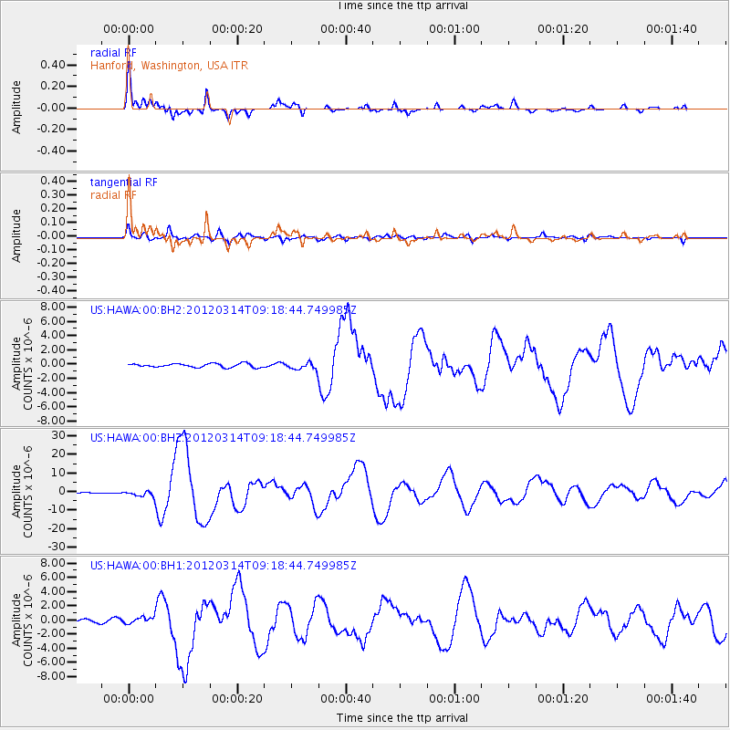
Earthquake location: Off East Coast Of Honshu, Japan
Earthquake latitude/longitude: 40.9/144.9
Earthquake time(UTC): 2012/03/14 (074) 09:08:35 GMT
Earthquake Depth: 12 km
Earthquake Magnitude: 6.7 MB, 6.9 MS, 6.9 MW, 7.0 MW
Earthquake Catalog/Contributor: WHDF/NEIC
Network: US United States National Seismic Network
Station: HAWA Hanford, Washington, USA
Lat/Lon: 46.39 N/119.53 W
Elevation: 364 m
Distance: 65.2 deg
Az: 49.391 deg
Baz: 303.736 deg
Ray Param: 0.058451593
Estimated Moho Depth: 36.25 km
Estimated Crust Vp/Vs: 1.67
Assumed Crust Vp: 6.419 km/s
Estimated Crust Vs: 3.838 km/s
Estimated Crust Poisson's Ratio: 0.22
Radial Match: 94.86679 %
Radial Bump: 308
Transverse Match: 80.085594 %
Transverse Bump: 400
SOD ConfigId: 558545
Insert Time: 2013-09-19 13:41:59.853 +0000
GWidth: 2.5
Max Bumps: 400
Tol: 0.001

Signal To Noise

ChannelStoNSTALTA
US:HAWA:00:BHZ:20120314T09:18:44.749985Z4.77336171.5109675E-63.165416E-7
US:HAWA:00:BH1:20120314T09:18:44.749985Z2.15200664.596992E-72.1361421E-7
US:HAWA:00:BH2:20120314T09:18:44.749985Z1.89923454.8762917E-72.5675035E-7
Arrivals
Ps4.0 SECOND
PpPs14 SECOND
PsPs/PpSs18 SECOND