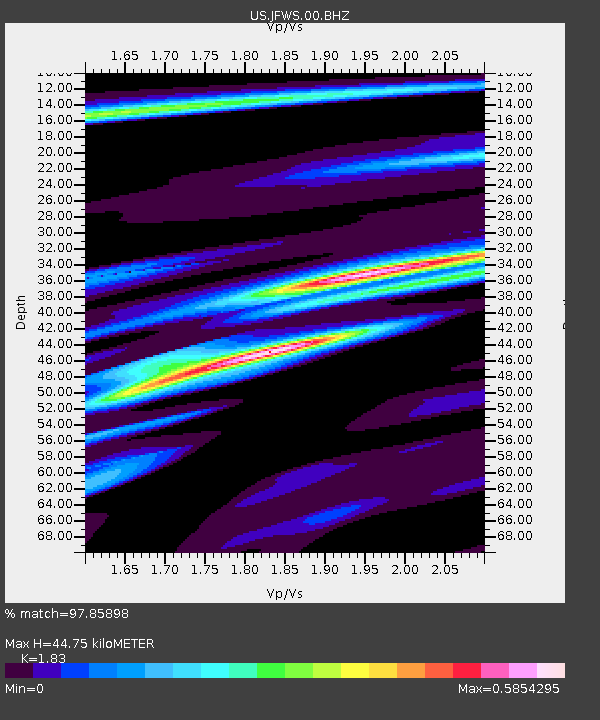
JFWS Jewell Farm, Wisconsin, USA - Earthquake Result Viewer

Earthquake location: Off East Coast Of Honshu, Japan
Earthquake latitude/longitude: 40.9/144.9
Earthquake time(UTC): 2012/03/14 (074) 09:08:35 GMT
Earthquake Depth: 12 km
Earthquake Magnitude: 6.7 MB, 6.9 MS, 6.9 MW, 7.0 MW
Earthquake Catalog/Contributor: WHDF/NEIC
Network: US United States National Seismic Network
Station: JFWS Jewell Farm, Wisconsin, USA
Lat/Lon: 42.91 N/90.25 W
Elevation: 335 m
Distance: 82.9 deg
Az: 37.44 deg
Baz: 321.142 deg
Ray Param: 0.046596367
Estimated Moho Depth: 44.75 km
Estimated Crust Vp/Vs: 1.83
Assumed Crust Vp: 6.53 km/s
Estimated Crust Vs: 3.569 km/s
Estimated Crust Poisson's Ratio: 0.29
Radial Match: 97.85898 %
Radial Bump: 306
Transverse Match: 90.75838 %
Transverse Bump: 400
SOD ConfigId: 558545
Insert Time: 2013-09-19 13:42:14.928 +0000
GWidth: 2.5
Max Bumps: 400
Tol: 0.001

Signal To Noise

ChannelStoNSTALTA
US:JFWS:00:BHZ:20120314T09:20:27.874985Z51.2053955.693128E-61.1118219E-7
US:JFWS:00:BH1:20120314T09:20:27.874985Z15.2745891.7277597E-61.1311334E-7
US:JFWS:00:BH2:20120314T09:20:27.874985Z13.7633191.4414852E-61.0473384E-7
Arrivals
Ps5.8 SECOND
PpPs19 SECOND
PsPs/PpSs25 SECOND