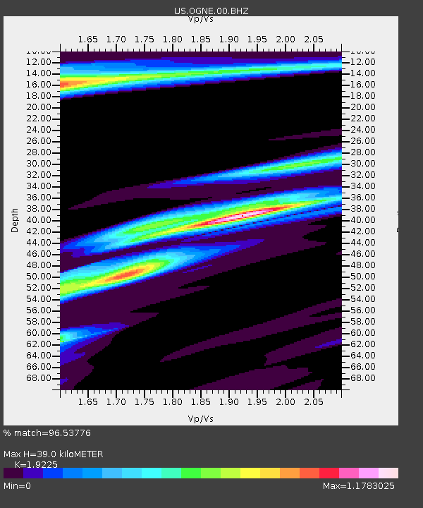
OGNE Ogallala, Nebraska, USA - Earthquake Result Viewer
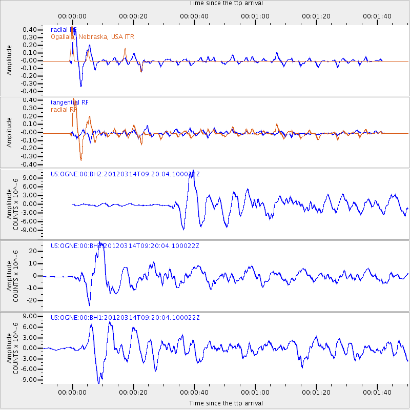
Earthquake location: Off East Coast Of Honshu, Japan
Earthquake latitude/longitude: 40.9/144.9
Earthquake time(UTC): 2012/03/14 (074) 09:08:35 GMT
Earthquake Depth: 12 km
Earthquake Magnitude: 6.7 MB, 6.9 MS, 6.9 MW, 7.0 MW
Earthquake Catalog/Contributor: WHDF/NEIC
Network: US United States National Seismic Network
Station: OGNE Ogallala, Nebraska, USA
Lat/Lon: 40.95 N/102.03 W
Elevation: 0.0 m
Distance: 78.4 deg
Az: 45.374 deg
Baz: 314.575 deg
Ray Param: 0.049662843
Estimated Moho Depth: 39.0 km
Estimated Crust Vp/Vs: 1.92
Assumed Crust Vp: 6.483 km/s
Estimated Crust Vs: 3.372 km/s
Estimated Crust Poisson's Ratio: 0.31
Radial Match: 96.53776 %
Radial Bump: 339
Transverse Match: 89.50157 %
Transverse Bump: 400
SOD ConfigId: 558545
Insert Time: 2013-09-19 13:42:54.550 +0000
GWidth: 2.5
Max Bumps: 400
Tol: 0.001

Signal To Noise

ChannelStoNSTALTA
US:OGNE:00:BHZ:20120314T09:20:04.100022Z28.3147683.3767362E-61.1925707E-7
US:OGNE:00:BH1:20120314T09:20:04.100022Z1.99988075.806385E-72.9033657E-7
US:OGNE:00:BH2:20120314T09:20:04.100022Z1.78340484.6177072E-72.5892646E-7
Arrivals
Ps5.7 SECOND
PpPs17 SECOND
PsPs/PpSs23 SECOND