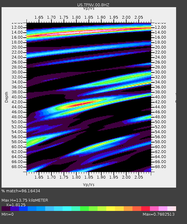
TPNV Topopah Spring, Nevada, USA - Earthquake Result Viewer
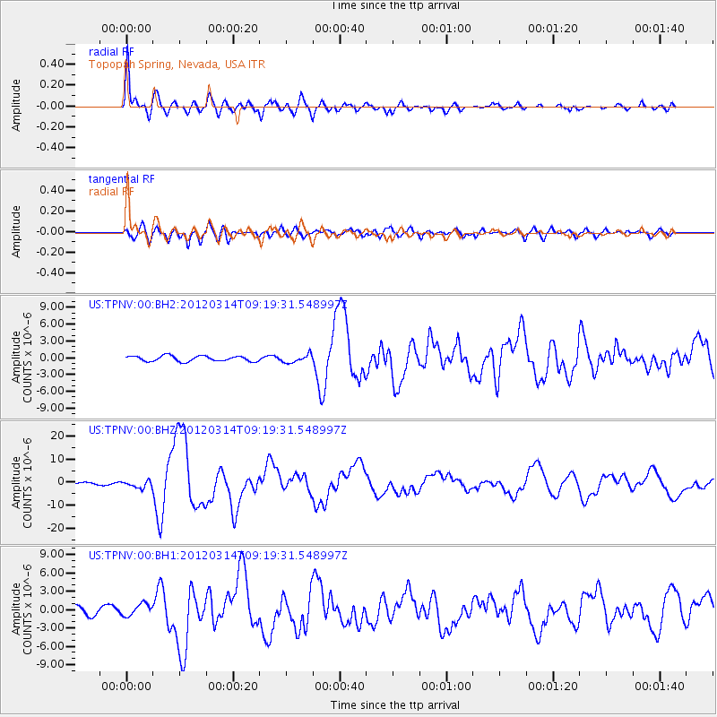
Earthquake location: Off East Coast Of Honshu, Japan
Earthquake latitude/longitude: 40.9/144.9
Earthquake time(UTC): 2012/03/14 (074) 09:08:35 GMT
Earthquake Depth: 12 km
Earthquake Magnitude: 6.7 MB, 6.9 MS, 6.9 MW, 7.0 MW
Earthquake Catalog/Contributor: WHDF/NEIC
Network: US United States National Seismic Network
Station: TPNV Topopah Spring, Nevada, USA
Lat/Lon: 36.95 N/116.25 W
Elevation: 1600 m
Distance: 72.7 deg
Az: 56.011 deg
Baz: 308.306 deg
Ray Param: 0.053480733
Estimated Moho Depth: 13.75 km
Estimated Crust Vp/Vs: 1.81
Assumed Crust Vp: 6.279 km/s
Estimated Crust Vs: 3.464 km/s
Estimated Crust Poisson's Ratio: 0.28
Radial Match: 96.16434 %
Radial Bump: 400
Transverse Match: 84.35103 %
Transverse Bump: 400
SOD ConfigId: 558545
Insert Time: 2013-09-19 13:43:05.815 +0000
GWidth: 2.5
Max Bumps: 400
Tol: 0.001

Signal To Noise

ChannelStoNSTALTA
US:TPNV:00:BHZ:20120314T09:19:31.548997Z2.9115121.5138113E-65.1993993E-7
US:TPNV:00:BH1:20120314T09:19:31.548997Z2.0701089.879309E-74.772364E-7
US:TPNV:00:BH2:20120314T09:19:31.548997Z1.4862847.2246615E-74.860889E-7
Arrivals
Ps1.8 SECOND
PpPs6.0 SECOND
PsPs/PpSs7.8 SECOND