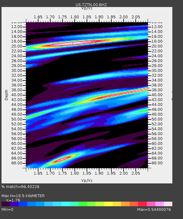
TZTN Tazewell, Tennessee, USA - Earthquake Result Viewer

Earthquake location: Off East Coast Of Honshu, Japan
Earthquake latitude/longitude: 40.9/144.9
Earthquake time(UTC): 2012/03/14 (074) 09:08:35 GMT
Earthquake Depth: 12 km
Earthquake Magnitude: 6.7 MB, 6.9 MS, 6.9 MW, 7.0 MW
Earthquake Catalog/Contributor: WHDF/NEIC
Network: US United States National Seismic Network
Station: TZTN Tazewell, Tennessee, USA
Lat/Lon: 36.54 N/83.55 W
Elevation: 394 m
Distance: 91.0 deg
Az: 37.098 deg
Baz: 325.398 deg
Ray Param: 0.041630518
Estimated Moho Depth: 18.5 km
Estimated Crust Vp/Vs: 1.79
Assumed Crust Vp: 6.476 km/s
Estimated Crust Vs: 3.618 km/s
Estimated Crust Poisson's Ratio: 0.27
Radial Match: 96.40226 %
Radial Bump: 291
Transverse Match: 85.4455 %
Transverse Bump: 400
SOD ConfigId: 558545
Insert Time: 2013-09-19 13:43:09.977 +0000
GWidth: 2.5
Max Bumps: 400
Tol: 0.001

Signal To Noise

ChannelStoNSTALTA
US:TZTN:00:BHZ:20120314T09:21:07.624985Z9.40838051.0029781E-61.06604766E-7
US:TZTN:00:BH1:20120314T09:21:07.624985Z2.87475752.3702671E-78.2451024E-8
US:TZTN:00:BH2:20120314T09:21:07.624985Z1.25548261.8849786E-71.5013977E-7
Arrivals
Ps2.3 SECOND
PpPs7.8 SECOND
PsPs/PpSs10 SECOND