You are here: Home > Network List > US - United States National Seismic Network Stations List
> Station WMOK Wichita Mountains, Oklahoma, USA > Earthquake Result Viewer
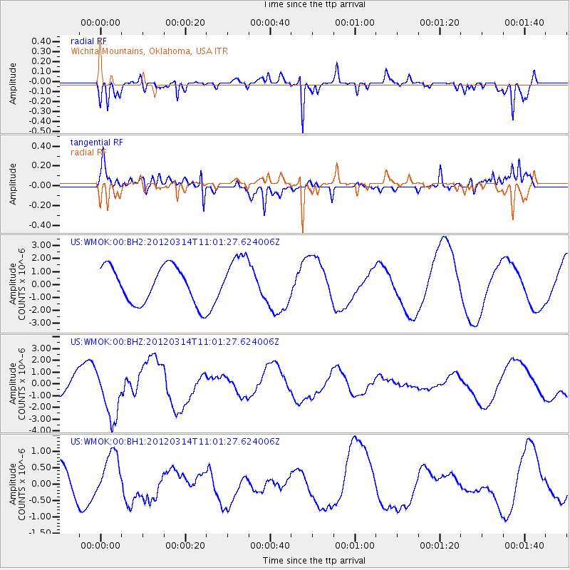
WMOK Wichita Mountains, Oklahoma, USA - Earthquake Result Viewer
*The percent match for this event was below the threshold and hence no stack was calculated.
| Earthquake location: |
Off East Coast Of Honshu, Japan |
| Earthquake latitude/longitude: |
40.8/144.8 |
| Earthquake time(UTC): |
2012/03/14 (074) 10:49:24 GMT |
| Earthquake Depth: |
10 km |
| Earthquake Magnitude: |
5.8 MB, 6.1 MW |
| Earthquake Catalog/Contributor: |
WHDF/NEIC |
|
| Network: |
US United States National Seismic Network |
| Station: |
WMOK Wichita Mountains, Oklahoma, USA |
| Lat/Lon: |
34.74 N/98.78 W |
| Elevation: |
486 m |
|
| Distance: |
84.8 deg |
| Az: |
47.759 deg |
| Baz: |
316.95 deg |
| Ray Param: |
$rayparam |
*The percent match for this event was below the threshold and hence was not used in the summary stack. |
|
| Radial Match: |
84.190735 % |
| Radial Bump: |
321 |
| Transverse Match: |
62.0766 % |
| Transverse Bump: |
400 |
| SOD ConfigId: |
558545 |
| Insert Time: |
2013-09-19 13:46:46.176 +0000 |
| GWidth: |
2.5 |
| Max Bumps: |
400 |
| Tol: |
0.001 |
|
Signal To Noise
| Channel | StoN | STA | LTA |
| US:WMOK:00:BHZ:20120314T11:01:27.624006Z | 2.7679758 | 2.1582216E-6 | 7.7971123E-7 |
| US:WMOK:00:BH1:20120314T11:01:27.624006Z | 0.99619067 | 6.48556E-7 | 6.51036E-7 |
| US:WMOK:00:BH2:20120314T11:01:27.624006Z | 1.3528949 | 1.9152894E-6 | 1.4156972E-6 |
| Arrivals |
| Ps | |
| PpPs | |
| PsPs/PpSs | |


