You are here: Home > Network List > US - United States National Seismic Network Stations List
> Station HAWA Hanford, Washington, USA > Earthquake Result Viewer
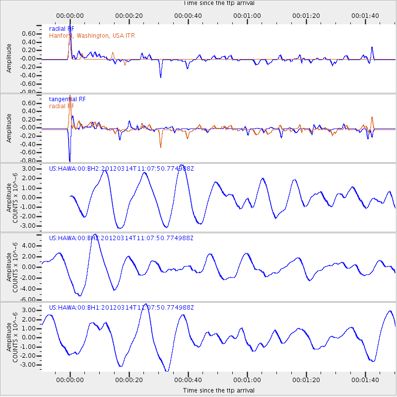
HAWA Hanford, Washington, USA - Earthquake Result Viewer
*The percent match for this event was below the threshold and hence no stack was calculated.
| Earthquake location: |
Off East Coast Of Honshu, Japan |
| Earthquake latitude/longitude: |
40.8/144.8 |
| Earthquake time(UTC): |
2012/03/14 (074) 10:57:40 GMT |
| Earthquake Depth: |
12 km |
| Earthquake Magnitude: |
5.6 MB |
| Earthquake Catalog/Contributor: |
WHDF/NEIC |
|
| Network: |
US United States National Seismic Network |
| Station: |
HAWA Hanford, Washington, USA |
| Lat/Lon: |
46.39 N/119.53 W |
| Elevation: |
364 m |
|
| Distance: |
65.3 deg |
| Az: |
49.287 deg |
| Baz: |
303.701 deg |
| Ray Param: |
$rayparam |
*The percent match for this event was below the threshold and hence was not used in the summary stack. |
|
| Radial Match: |
61.62936 % |
| Radial Bump: |
400 |
| Transverse Match: |
72.75949 % |
| Transverse Bump: |
400 |
| SOD ConfigId: |
558545 |
| Insert Time: |
2013-09-19 13:49:39.396 +0000 |
| GWidth: |
2.5 |
| Max Bumps: |
400 |
| Tol: |
0.001 |
|
Signal To Noise
| Channel | StoN | STA | LTA |
| US:HAWA:00:BHZ:20120314T11:07:50.774988Z | 2.5390162 | 3.8846156E-6 | 1.5299687E-6 |
| US:HAWA:00:BH1:20120314T11:07:50.774988Z | 1.0663933 | 1.6615923E-6 | 1.5581421E-6 |
| US:HAWA:00:BH2:20120314T11:07:50.774988Z | 1.158282 | 2.0477707E-6 | 1.7679379E-6 |
| Arrivals |
| Ps | |
| PpPs | |
| PsPs/PpSs | |


