You are here: Home > Network List > US - United States National Seismic Network Stations List
> Station DGMT Dagmar, Montana, USA > Earthquake Result Viewer
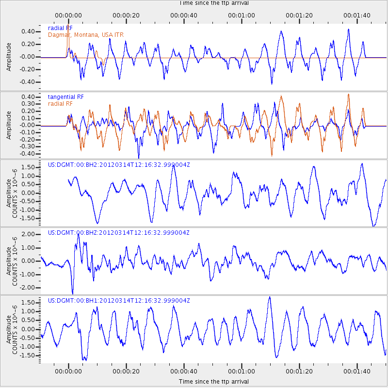
DGMT Dagmar, Montana, USA - Earthquake Result Viewer
*The percent match for this event was below the threshold and hence no stack was calculated.
| Earthquake location: |
Near East Coast Of Honshu, Japan |
| Earthquake latitude/longitude: |
35.7/140.7 |
| Earthquake time(UTC): |
2012/03/14 (074) 12:05:04 GMT |
| Earthquake Depth: |
10 km |
| Earthquake Magnitude: |
5.7 MB, 5.6 MS, 6.0 MW |
| Earthquake Catalog/Contributor: |
WHDF/NEIC |
|
| Network: |
US United States National Seismic Network |
| Station: |
DGMT Dagmar, Montana, USA |
| Lat/Lon: |
48.47 N/104.20 W |
| Elevation: |
0.0 m |
|
| Distance: |
78.3 deg |
| Az: |
37.988 deg |
| Baz: |
311.158 deg |
| Ray Param: |
$rayparam |
*The percent match for this event was below the threshold and hence was not used in the summary stack. |
|
| Radial Match: |
65.43807 % |
| Radial Bump: |
400 |
| Transverse Match: |
65.97206 % |
| Transverse Bump: |
400 |
| SOD ConfigId: |
558545 |
| Insert Time: |
2013-09-19 13:53:19.532 +0000 |
| GWidth: |
2.5 |
| Max Bumps: |
400 |
| Tol: |
0.001 |
|
Signal To Noise
| Channel | StoN | STA | LTA |
| US:DGMT:00:BHZ:20120314T12:16:32.999004Z | 4.8087597 | 1.1727592E-6 | 2.4387978E-7 |
| US:DGMT:00:BH1:20120314T12:16:32.999004Z | 0.7481399 | 5.384559E-7 | 7.1972613E-7 |
| US:DGMT:00:BH2:20120314T12:16:32.999004Z | 1.2337583 | 7.911329E-7 | 6.4123816E-7 |
| Arrivals |
| Ps | |
| PpPs | |
| PsPs/PpSs | |


