You are here: Home > Network List > US - United States National Seismic Network Stations List
> Station EGMT Eagleton, Montana, USA > Earthquake Result Viewer
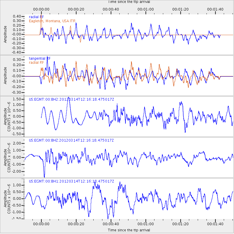
EGMT Eagleton, Montana, USA - Earthquake Result Viewer
*The percent match for this event was below the threshold and hence no stack was calculated.
| Earthquake location: |
Near East Coast Of Honshu, Japan |
| Earthquake latitude/longitude: |
35.7/140.7 |
| Earthquake time(UTC): |
2012/03/14 (074) 12:05:04 GMT |
| Earthquake Depth: |
10 km |
| Earthquake Magnitude: |
5.7 MB, 5.6 MS, 6.0 MW |
| Earthquake Catalog/Contributor: |
WHDF/NEIC |
|
| Network: |
US United States National Seismic Network |
| Station: |
EGMT Eagleton, Montana, USA |
| Lat/Lon: |
48.02 N/109.75 W |
| Elevation: |
1055 m |
|
| Distance: |
75.7 deg |
| Az: |
40.763 deg |
| Baz: |
307.647 deg |
| Ray Param: |
$rayparam |
*The percent match for this event was below the threshold and hence was not used in the summary stack. |
|
| Radial Match: |
53.783215 % |
| Radial Bump: |
400 |
| Transverse Match: |
53.596035 % |
| Transverse Bump: |
400 |
| SOD ConfigId: |
558545 |
| Insert Time: |
2013-09-19 13:53:27.269 +0000 |
| GWidth: |
2.5 |
| Max Bumps: |
400 |
| Tol: |
0.001 |
|
Signal To Noise
| Channel | StoN | STA | LTA |
| US:EGMT:00:BHZ:20120314T12:16:18.475017Z | 2.3017538 | 9.69841E-7 | 4.2134877E-7 |
| US:EGMT:00:BH1:20120314T12:16:18.475017Z | 0.9748723 | 4.6151686E-7 | 4.7341263E-7 |
| US:EGMT:00:BH2:20120314T12:16:18.475017Z | 0.44495702 | 2.8178445E-7 | 6.332847E-7 |
| Arrivals |
| Ps | |
| PpPs | |
| PsPs/PpSs | |


