You are here: Home > Network List > US - United States National Seismic Network Stations List
> Station MSO Missoula, Montana, USA > Earthquake Result Viewer
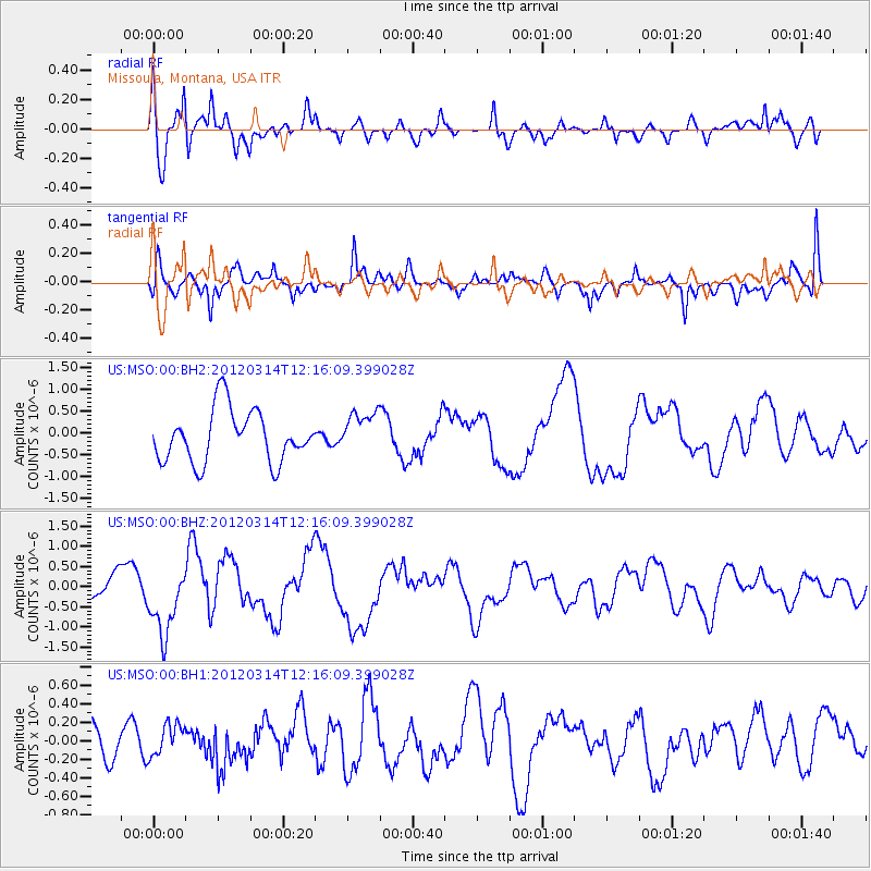
MSO Missoula, Montana, USA - Earthquake Result Viewer
*The percent match for this event was below the threshold and hence no stack was calculated.
| Earthquake location: |
Near East Coast Of Honshu, Japan |
| Earthquake latitude/longitude: |
35.7/140.7 |
| Earthquake time(UTC): |
2012/03/14 (074) 12:05:04 GMT |
| Earthquake Depth: |
10 km |
| Earthquake Magnitude: |
5.7 MB, 5.6 MS, 6.0 MW |
| Earthquake Catalog/Contributor: |
WHDF/NEIC |
|
| Network: |
US United States National Seismic Network |
| Station: |
MSO Missoula, Montana, USA |
| Lat/Lon: |
46.83 N/113.94 W |
| Elevation: |
1264 m |
|
| Distance: |
74.1 deg |
| Az: |
43.508 deg |
| Baz: |
305.29 deg |
| Ray Param: |
$rayparam |
*The percent match for this event was below the threshold and hence was not used in the summary stack. |
|
| Radial Match: |
74.31824 % |
| Radial Bump: |
400 |
| Transverse Match: |
72.613304 % |
| Transverse Bump: |
400 |
| SOD ConfigId: |
558545 |
| Insert Time: |
2013-09-19 13:53:55.334 +0000 |
| GWidth: |
2.5 |
| Max Bumps: |
400 |
| Tol: |
0.001 |
|
Signal To Noise
| Channel | StoN | STA | LTA |
| US:MSO:00:BHZ:20120314T12:16:09.399028Z | 2.2029068 | 8.416242E-7 | 3.8205167E-7 |
| US:MSO:00:BH1:20120314T12:16:09.399028Z | 0.44929284 | 1.7350983E-7 | 3.8618427E-7 |
| US:MSO:00:BH2:20120314T12:16:09.399028Z | 0.8023097 | 4.764147E-7 | 5.93804E-7 |
| Arrivals |
| Ps | |
| PpPs | |
| PsPs/PpSs | |


