You are here: Home > Network List > US - United States National Seismic Network Stations List
> Station TPNV Topopah Spring, Nevada, USA > Earthquake Result Viewer
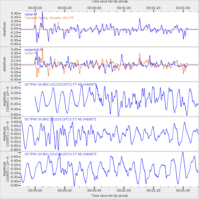
TPNV Topopah Spring, Nevada, USA - Earthquake Result Viewer
*The percent match for this event was below the threshold and hence no stack was calculated.
| Earthquake location: |
Samoa Islands Region |
| Earthquake latitude/longitude: |
-14.6/-175.7 |
| Earthquake time(UTC): |
2012/03/19 (079) 23:46:35 GMT |
| Earthquake Depth: |
28 km |
| Earthquake Magnitude: |
5.9 MW, 5.5 MB, 5.5 MS, 5.7 MW |
| Earthquake Catalog/Contributor: |
NEIC PDE/NEIC PDE-M |
|
| Network: |
US United States National Seismic Network |
| Station: |
TPNV Topopah Spring, Nevada, USA |
| Lat/Lon: |
36.95 N/116.25 W |
| Elevation: |
1600 m |
|
| Distance: |
75.9 deg |
| Az: |
45.351 deg |
| Baz: |
239.278 deg |
| Ray Param: |
$rayparam |
*The percent match for this event was below the threshold and hence was not used in the summary stack. |
|
| Radial Match: |
61.42822 % |
| Radial Bump: |
400 |
| Transverse Match: |
76.97645 % |
| Transverse Bump: |
400 |
| SOD ConfigId: |
558545 |
| Insert Time: |
2013-09-19 14:13:56.409 +0000 |
| GWidth: |
2.5 |
| Max Bumps: |
400 |
| Tol: |
0.001 |
|
Signal To Noise
| Channel | StoN | STA | LTA |
| US:TPNV:00:BHZ:20120319T23:57:48.048987Z | 1.0811875 | 3.524326E-7 | 3.2596807E-7 |
| US:TPNV:00:BH1:20120319T23:57:48.048987Z | 1.2321178 | 2.9483934E-7 | 2.392948E-7 |
| US:TPNV:00:BH2:20120319T23:57:48.048987Z | 1.0944874 | 2.936439E-7 | 2.6829352E-7 |
| Arrivals |
| Ps | |
| PpPs | |
| PsPs/PpSs | |


