You are here: Home > Network List > US - United States National Seismic Network Stations List
> Station WMOK Wichita Mountains, Oklahoma, USA > Earthquake Result Viewer
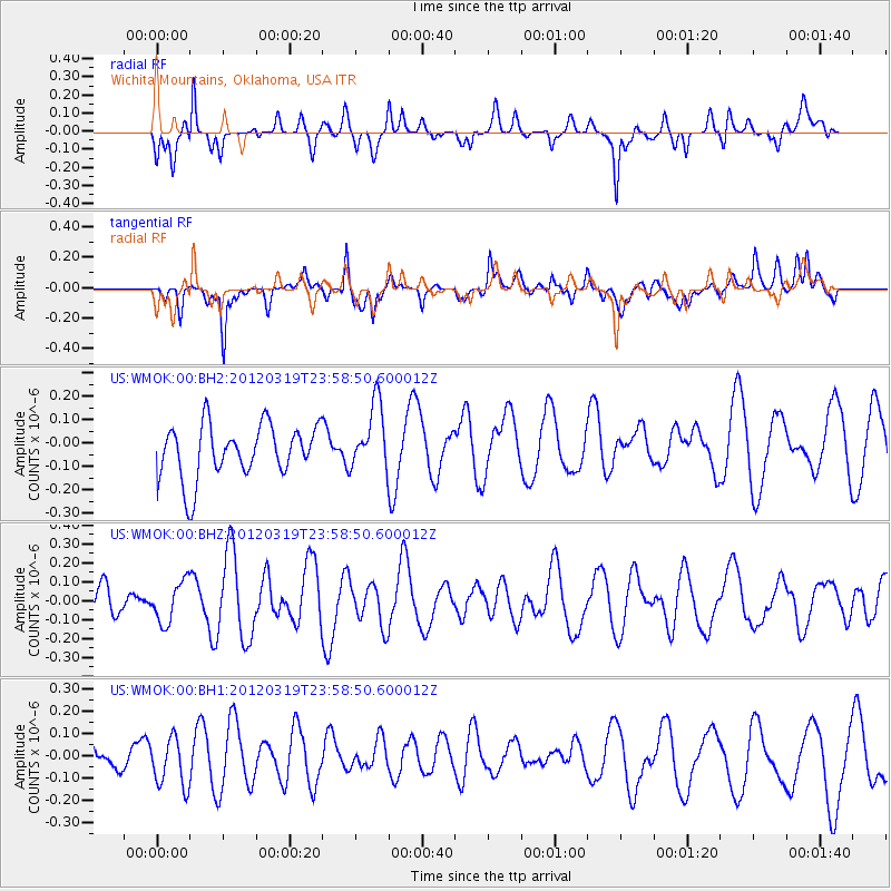
WMOK Wichita Mountains, Oklahoma, USA - Earthquake Result Viewer
*The percent match for this event was below the threshold and hence no stack was calculated.
| Earthquake location: |
Samoa Islands Region |
| Earthquake latitude/longitude: |
-14.6/-175.7 |
| Earthquake time(UTC): |
2012/03/19 (079) 23:46:35 GMT |
| Earthquake Depth: |
28 km |
| Earthquake Magnitude: |
5.9 MW, 5.5 MB, 5.5 MS, 5.7 MW |
| Earthquake Catalog/Contributor: |
NEIC PDE/NEIC PDE-M |
|
| Network: |
US United States National Seismic Network |
| Station: |
WMOK Wichita Mountains, Oklahoma, USA |
| Lat/Lon: |
34.74 N/98.78 W |
| Elevation: |
486 m |
|
| Distance: |
87.8 deg |
| Az: |
53.396 deg |
| Baz: |
250.666 deg |
| Ray Param: |
$rayparam |
*The percent match for this event was below the threshold and hence was not used in the summary stack. |
|
| Radial Match: |
56.88141 % |
| Radial Bump: |
400 |
| Transverse Match: |
56.336845 % |
| Transverse Bump: |
400 |
| SOD ConfigId: |
558545 |
| Insert Time: |
2013-09-19 14:14:02.306 +0000 |
| GWidth: |
2.5 |
| Max Bumps: |
400 |
| Tol: |
0.001 |
|
Signal To Noise
| Channel | StoN | STA | LTA |
| US:WMOK:00:BHZ:20120319T23:58:50.600012Z | 0.6949675 | 1.0867809E-7 | 1.5637866E-7 |
| US:WMOK:00:BH1:20120319T23:58:50.600012Z | 1.7340521 | 1.1294533E-7 | 6.513376E-8 |
| US:WMOK:00:BH2:20120319T23:58:50.600012Z | 1.2716721 | 1.442909E-7 | 1.1346548E-7 |
| Arrivals |
| Ps | |
| PpPs | |
| PsPs/PpSs | |


