You are here: Home > Network List > CU - Caribbean Network (USGS) Stations List
> Station BBGH Gun Hill, Barbados > Earthquake Result Viewer
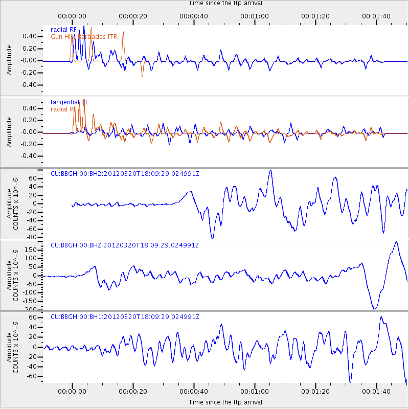
BBGH Gun Hill, Barbados - Earthquake Result Viewer
*The percent match for this event was below the threshold and hence no stack was calculated.
| Earthquake location: |
Near Coast Of Guerrero, Mexico |
| Earthquake latitude/longitude: |
16.5/-98.2 |
| Earthquake time(UTC): |
2012/03/20 (080) 18:02:47 GMT |
| Earthquake Depth: |
20 km |
| Earthquake Magnitude: |
6.6 MB, 7.6 MS, 7.4 MW, 7.4 MW |
| Earthquake Catalog/Contributor: |
WHDF/NEIC |
|
| Network: |
CU Caribbean Network (USGS) |
| Station: |
BBGH Gun Hill, Barbados |
| Lat/Lon: |
13.14 N/59.56 W |
| Elevation: |
180 m |
|
| Distance: |
37.5 deg |
| Az: |
89.795 deg |
| Baz: |
279.992 deg |
| Ray Param: |
$rayparam |
*The percent match for this event was below the threshold and hence was not used in the summary stack. |
|
| Radial Match: |
83.81122 % |
| Radial Bump: |
400 |
| Transverse Match: |
40.68144 % |
| Transverse Bump: |
400 |
| SOD ConfigId: |
558545 |
| Insert Time: |
2013-09-19 14:17:57.454 +0000 |
| GWidth: |
2.5 |
| Max Bumps: |
400 |
| Tol: |
0.001 |
|
Signal To Noise
| Channel | StoN | STA | LTA |
| CU:BBGH:00:BHZ:20120320T18:09:29.024991Z | 5.1700644 | 9.74077E-6 | 1.8840713E-6 |
| CU:BBGH:00:BH1:20120320T18:09:29.024991Z | 1.1885663 | 2.6332398E-6 | 2.2154757E-6 |
| CU:BBGH:00:BH2:20120320T18:09:29.024991Z | 1.2046615 | 2.6030002E-6 | 2.1607732E-6 |
| Arrivals |
| Ps | |
| PpPs | |
| PsPs/PpSs | |


