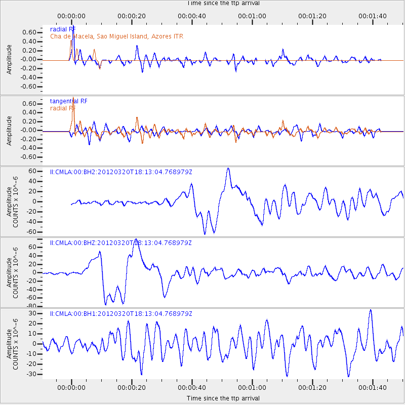
CMLA Cha de Macela, Sao Miguel Island, Azores - Earthquake Result Viewer
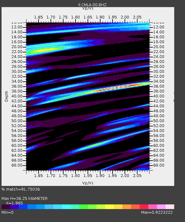
Earthquake location: Near Coast Of Guerrero, Mexico
Earthquake latitude/longitude: 16.5/-98.2
Earthquake time(UTC): 2012/03/20 (080) 18:02:47 GMT
Earthquake Depth: 20 km
Earthquake Magnitude: 6.6 MB, 7.6 MS, 7.4 MW, 7.4 MW
Earthquake Catalog/Contributor: WHDF/NEIC
Network: II Global Seismograph Network (GSN - IRIS/IDA)
Station: CMLA Cha de Macela, Sao Miguel Island, Azores
Lat/Lon: 37.76 N/25.52 W
Elevation: 429 m
Distance: 66.5 deg
Az: 55.576 deg
Baz: 273.105 deg
Ray Param: 0.05752669
Estimated Moho Depth: 36.25 km
Estimated Crust Vp/Vs: 1.97
Assumed Crust Vp: 4.802 km/s
Estimated Crust Vs: 2.444 km/s
Estimated Crust Poisson's Ratio: 0.33
Radial Match: 91.75036 %
Radial Bump: 362
Transverse Match: 81.09138 %
Transverse Bump: 400
SOD ConfigId: 558545
Insert Time: 2013-09-19 14:18:07.469 +0000
GWidth: 2.5
Max Bumps: 400
Tol: 0.001

Signal To Noise

ChannelStoNSTALTA
II:CMLA:00:BHZ:20120320T18:13:04.768979Z3.02481724.11836E-61.3615235E-6
II:CMLA:00:BH1:20120320T18:13:04.768979Z1.29278124.2998236E-63.3260258E-6
II:CMLA:00:BH2:20120320T18:13:04.768979Z1.99859654.5941515E-62.298689E-6
Arrivals
Ps7.4 SECOND
PpPs22 SECOND
PsPs/PpSs29 SECOND