PAB San Pablo, Spain - Earthquake Result Viewer
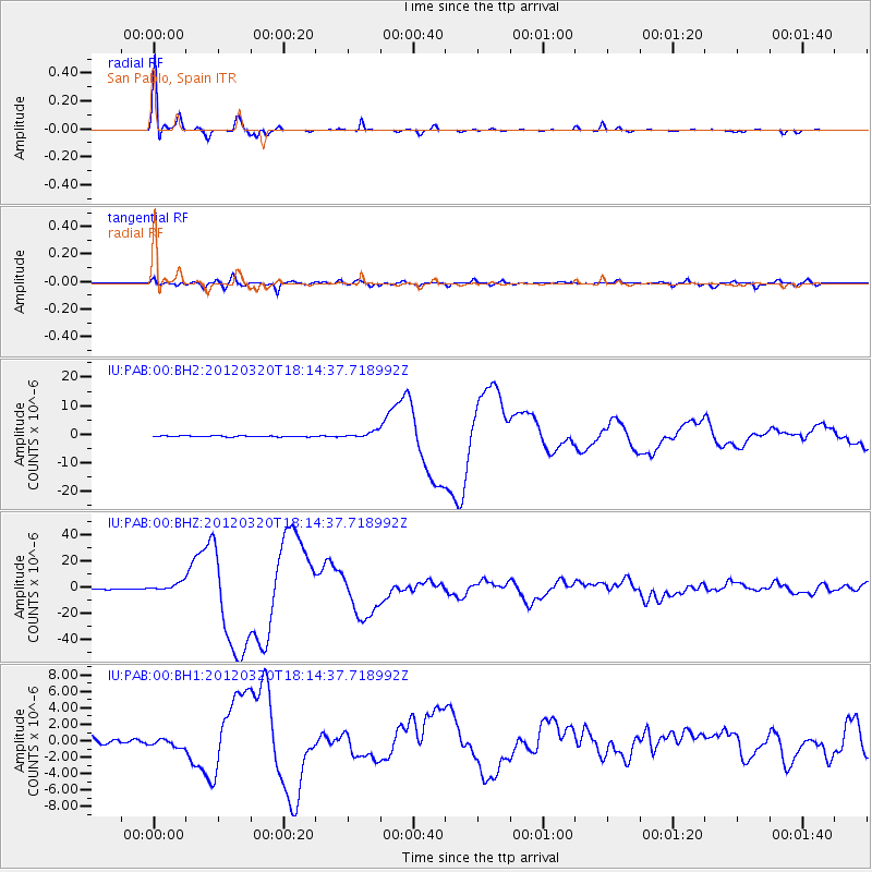
Earthquake location: Near Coast Of Guerrero, Mexico
Earthquake latitude/longitude: 16.5/-98.2
Earthquake time(UTC): 2012/03/20 (080) 18:02:47 GMT
Earthquake Depth: 20 km
Earthquake Magnitude: 6.6 MB, 7.6 MS, 7.4 MW, 7.4 MW
Earthquake Catalog/Contributor: WHDF/NEIC
Network: IU Global Seismograph Network (GSN - IRIS/USGS)
Station: PAB San Pablo, Spain
Lat/Lon: 39.54 N/4.35 W
Elevation: 950 m
Distance: 82.6 deg
Az: 51.071 deg
Baz: 285.16 deg
Ray Param: 0.046753727
Estimated Moho Depth: 30.75 km
Estimated Crust Vp/Vs: 1.82
Assumed Crust Vp: 6.276 km/s
Estimated Crust Vs: 3.458 km/s
Estimated Crust Poisson's Ratio: 0.28
Radial Match: 99.01345 %
Radial Bump: 247
Transverse Match: 91.99071 %
Transverse Bump: 400
SOD ConfigId: 558545
Insert Time: 2013-09-19 14:18:43.621 +0000
GWidth: 2.5
Max Bumps: 400
Tol: 0.001

Signal To Noise

ChannelStoNSTALTA
IU:PAB:00:BHZ:20120320T18:14:37.718992Z10.4122193.3084088E-63.1774292E-7
IU:PAB:00:BH1:20120320T18:14:37.718992Z1.49201045.23996E-73.512013E-7
IU:PAB:00:BH2:20120320T18:14:37.718992Z6.50221971.15487E-61.7761167E-7
Arrivals
Ps4.1 SECOND
PpPs13 SECOND
PsPs/PpSs18 SECOND