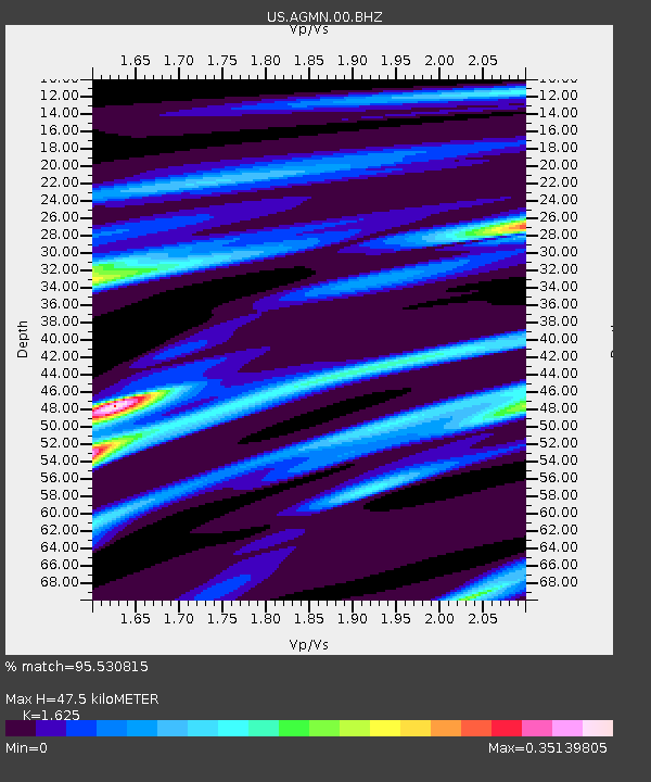
AGMN Agassiz National Wildlife Refuge, Minnesota, USA - Earthquake Result Viewer
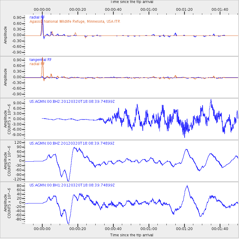
Earthquake location: Near Coast Of Guerrero, Mexico
Earthquake latitude/longitude: 16.5/-98.2
Earthquake time(UTC): 2012/03/20 (080) 18:02:47 GMT
Earthquake Depth: 20 km
Earthquake Magnitude: 6.6 MB, 7.6 MS, 7.4 MW, 7.4 MW
Earthquake Catalog/Contributor: WHDF/NEIC
Network: US United States National Seismic Network
Station: AGMN Agassiz National Wildlife Refuge, Minnesota, USA
Lat/Lon: 48.30 N/95.86 W
Elevation: 351 m
Distance: 31.8 deg
Az: 3.004 deg
Baz: 184.319 deg
Ray Param: 0.078912795
Estimated Moho Depth: 47.5 km
Estimated Crust Vp/Vs: 1.62
Assumed Crust Vp: 6.419 km/s
Estimated Crust Vs: 3.95 km/s
Estimated Crust Poisson's Ratio: 0.20
Radial Match: 95.530815 %
Radial Bump: 176
Transverse Match: 77.446335 %
Transverse Bump: 400
SOD ConfigId: 558545
Insert Time: 2013-09-19 14:19:07.393 +0000
GWidth: 2.5
Max Bumps: 400
Tol: 0.001

Signal To Noise

ChannelStoNSTALTA
US:AGMN:00:BHZ:20120320T18:08:39.74899Z83.790522.088052E-52.4919905E-7
US:AGMN:00:BH1:20120320T18:08:39.74899Z43.3597681.4708708E-53.3922478E-7
US:AGMN:00:BH2:20120320T18:08:39.74899Z1.60404444.2473462E-72.6478983E-7
Arrivals
Ps5.0 SECOND
PpPs18 SECOND
PsPs/PpSs23 SECOND