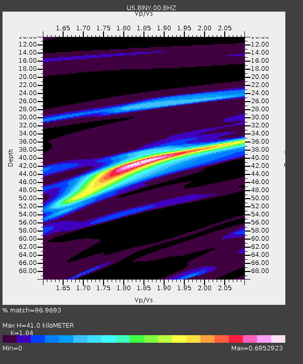
BINY Binghamton, New York, USA - Earthquake Result Viewer
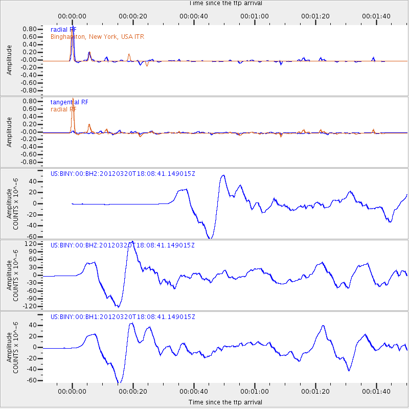
Earthquake location: Near Coast Of Guerrero, Mexico
Earthquake latitude/longitude: 16.5/-98.2
Earthquake time(UTC): 2012/03/20 (080) 18:02:47 GMT
Earthquake Depth: 20 km
Earthquake Magnitude: 6.6 MB, 7.6 MS, 7.4 MW, 7.4 MW
Earthquake Catalog/Contributor: WHDF/NEIC
Network: US United States National Seismic Network
Station: BINY Binghamton, New York, USA
Lat/Lon: 42.20 N/75.99 W
Elevation: 498 m
Distance: 31.9 deg
Az: 32.125 deg
Baz: 223.359 deg
Ray Param: 0.07884507
Estimated Moho Depth: 41.0 km
Estimated Crust Vp/Vs: 1.84
Assumed Crust Vp: 6.419 km/s
Estimated Crust Vs: 3.489 km/s
Estimated Crust Poisson's Ratio: 0.29
Radial Match: 96.9693 %
Radial Bump: 180
Transverse Match: 86.25133 %
Transverse Bump: 400
SOD ConfigId: 558545
Insert Time: 2013-09-19 14:19:07.837 +0000
GWidth: 2.5
Max Bumps: 400
Tol: 0.001

Signal To Noise

ChannelStoNSTALTA
US:BINY:00:BHZ:20120320T18:08:41.149015Z63.5104981.88131E-52.9622032E-7
US:BINY:00:BH1:20120320T18:08:41.149015Z22.569177.607623E-63.3708034E-7
US:BINY:00:BH2:20120320T18:08:41.149015Z26.4675988.3323885E-63.1481468E-7
Arrivals
Ps5.8 SECOND
PpPs17 SECOND
PsPs/PpSs23 SECOND