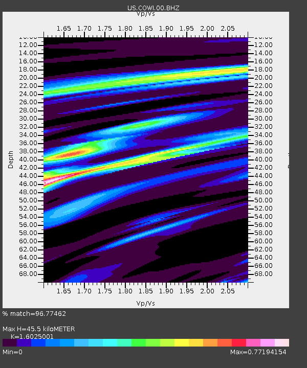
COWI Conover, Wisconsin, USA - Earthquake Result Viewer

Earthquake location: Near Coast Of Guerrero, Mexico
Earthquake latitude/longitude: 16.5/-98.2
Earthquake time(UTC): 2012/03/20 (080) 18:02:47 GMT
Earthquake Depth: 20 km
Earthquake Magnitude: 6.6 MB, 7.6 MS, 7.4 MW, 7.4 MW
Earthquake Catalog/Contributor: WHDF/NEIC
Network: US United States National Seismic Network
Station: COWI Conover, Wisconsin, USA
Lat/Lon: 46.10 N/89.14 W
Elevation: 523 m
Distance: 30.5 deg
Az: 12.522 deg
Baz: 197.394 deg
Ray Param: 0.079308465
Estimated Moho Depth: 45.5 km
Estimated Crust Vp/Vs: 1.60
Assumed Crust Vp: 6.467 km/s
Estimated Crust Vs: 4.035 km/s
Estimated Crust Poisson's Ratio: 0.18
Radial Match: 96.77462 %
Radial Bump: 227
Transverse Match: 89.46764 %
Transverse Bump: 400
SOD ConfigId: 558545
Insert Time: 2013-09-19 14:19:15.342 +0000
GWidth: 2.5
Max Bumps: 400
Tol: 0.001

Signal To Noise

ChannelStoNSTALTA
US:COWI:00:BHZ:20120320T18:08:28.348997Z82.020642.3925239E-52.916978E-7
US:COWI:00:BH1:20120320T18:08:28.348997Z91.4918751.6175049E-51.7679218E-7
US:COWI:00:BH2:20120320T18:08:28.348997Z19.2729363.953158E-62.0511446E-7
Arrivals
Ps4.6 SECOND
PpPs17 SECOND
PsPs/PpSs21 SECOND