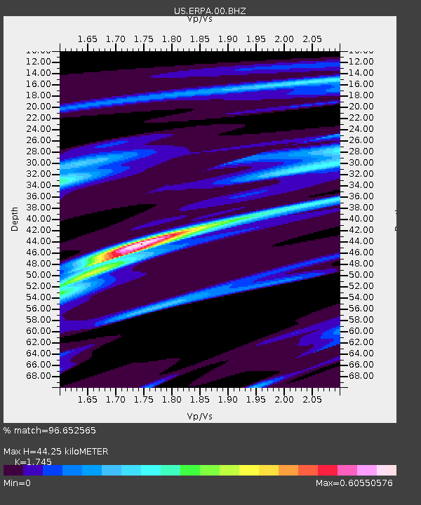
ERPA Erie, Pennsylvania, USA - Earthquake Result Viewer

Earthquake location: Near Coast Of Guerrero, Mexico
Earthquake latitude/longitude: 16.5/-98.2
Earthquake time(UTC): 2012/03/20 (080) 18:02:47 GMT
Earthquake Depth: 20 km
Earthquake Magnitude: 6.6 MB, 7.6 MS, 7.4 MW, 7.4 MW
Earthquake Catalog/Contributor: WHDF/NEIC
Network: US United States National Seismic Network
Station: ERPA Erie, Pennsylvania, USA
Lat/Lon: 42.12 N/79.99 W
Elevation: 306 m
Distance: 30.0 deg
Az: 27.804 deg
Baz: 216.975 deg
Ray Param: 0.079447016
Estimated Moho Depth: 44.25 km
Estimated Crust Vp/Vs: 1.75
Assumed Crust Vp: 6.419 km/s
Estimated Crust Vs: 3.679 km/s
Estimated Crust Poisson's Ratio: 0.26
Radial Match: 96.652565 %
Radial Bump: 224
Transverse Match: 66.17083 %
Transverse Bump: 400
SOD ConfigId: 558545
Insert Time: 2013-09-19 14:19:24.253 +0000
GWidth: 2.5
Max Bumps: 400
Tol: 0.001

Signal To Noise

ChannelStoNSTALTA
US:ERPA:00:BHZ:20120320T18:08:23.699003Z84.043592.4832312E-52.9546945E-7
US:ERPA:00:BH1:20120320T18:08:23.699003Z81.333291.3488323E-51.6584012E-7
US:ERPA:00:BH2:20120320T18:08:23.699003Z54.146391.0888653E-52.0109657E-7
Arrivals
Ps5.6 SECOND
PpPs17 SECOND
PsPs/PpSs23 SECOND