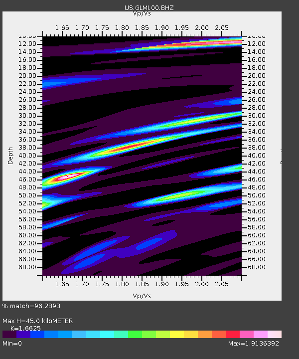
GLMI Grayling, Michigan, USA - Earthquake Result Viewer

Earthquake location: Near Coast Of Guerrero, Mexico
Earthquake latitude/longitude: 16.5/-98.2
Earthquake time(UTC): 2012/03/20 (080) 18:02:47 GMT
Earthquake Depth: 20 km
Earthquake Magnitude: 6.6 MB, 7.6 MS, 7.4 MW, 7.4 MW
Earthquake Catalog/Contributor: WHDF/NEIC
Network: US United States National Seismic Network
Station: GLMI Grayling, Michigan, USA
Lat/Lon: 44.82 N/84.62 W
Elevation: 387 m
Distance: 30.5 deg
Az: 19.279 deg
Baz: 206.43 deg
Ray Param: 0.079307444
Estimated Moho Depth: 45.0 km
Estimated Crust Vp/Vs: 1.66
Assumed Crust Vp: 6.483 km/s
Estimated Crust Vs: 3.899 km/s
Estimated Crust Poisson's Ratio: 0.22
Radial Match: 96.2893 %
Radial Bump: 400
Transverse Match: 62.079926 %
Transverse Bump: 400
SOD ConfigId: 558545
Insert Time: 2013-09-19 14:19:29.622 +0000
GWidth: 2.5
Max Bumps: 400
Tol: 0.001

Signal To Noise

ChannelStoNSTALTA
US:GLMI:00:BHZ:20120320T18:08:28.374998Z82.036952.9041756E-53.5400822E-7
US:GLMI:00:BH1:20120320T18:08:28.374998Z43.460511.8636274E-54.288094E-7
US:GLMI:00:BH2:20120320T18:08:28.374998Z20.8802241.0910339E-55.225202E-7
Arrivals
Ps5.0 SECOND
PpPs17 SECOND
PsPs/PpSs22 SECOND