You are here: Home > Network List > IU - Global Seismograph Network (GSN - IRIS/USGS) Stations List
> Station GNI Garni, Armenia > Earthquake Result Viewer
GNI Garni, Armenia - Earthquake Result Viewer
| Earthquake location: |
Southwest Indian Ridge |
| Earthquake latitude/longitude: |
-30.0/60.7 |
| Earthquake time(UTC): |
2012/03/26 (086) 16:58:10 GMT |
| Earthquake Depth: |
10 km |
| Earthquake Magnitude: |
5.7 MB, 5.3 MS, 5.6 MW, 5.6 MW |
| Earthquake Catalog/Contributor: |
WHDF/NEIC |
|
| Network: |
IU Global Seismograph Network (GSN - IRIS/USGS) |
| Station: |
GNI Garni, Armenia |
| Lat/Lon: |
40.15 N/44.74 E |
| Elevation: |
1609 m |
|
| Distance: |
71.4 deg |
| Az: |
347.188 deg |
| Baz: |
165.471 deg |
| Ray Param: |
0.054367788 |
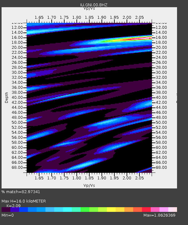
| Estimated Moho Depth: |
16.0 km |
| Estimated Crust Vp/Vs: |
2.09 |
| Assumed Crust Vp: |
6.291 km/s |
| Estimated Crust Vs: |
3.01 km/s |
| Estimated Crust Poisson's Ratio: |
0.35 |
|
| Radial Match: |
82.97341 % |
| Radial Bump: |
400 |
| Transverse Match: |
86.39928 % |
| Transverse Bump: |
400 |
| SOD ConfigId: |
558545 |
| Insert Time: |
2013-09-19 14:33:06.114 +0000 |
| GWidth: |
2.5 |
| Max Bumps: |
400 |
| Tol: |
0.001 |
|
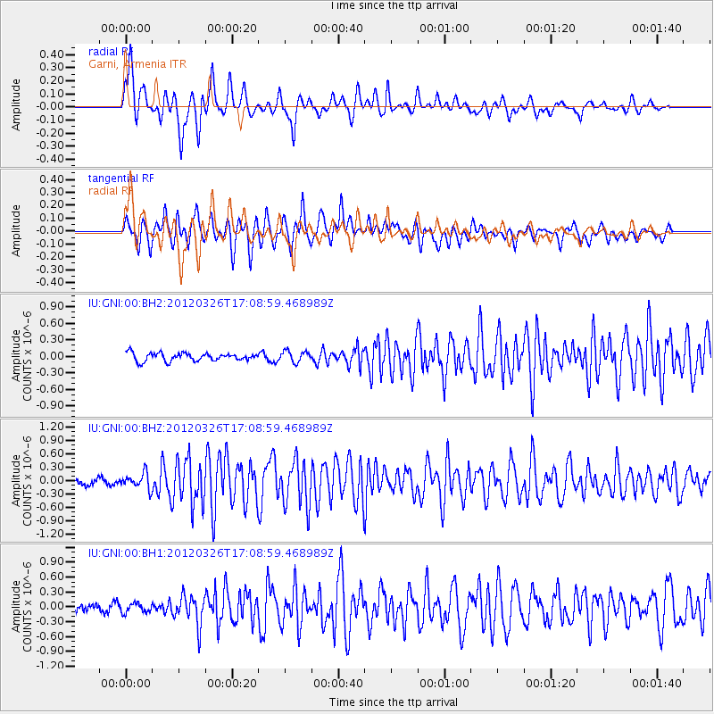
Signal To Noise
| Channel | StoN | STA | LTA |
| IU:GNI:00:BHZ:20120326T17:08:59.468989Z | 1.8696991 | 1.7843011E-7 | 9.5432526E-8 |
| IU:GNI:00:BH1:20120326T17:08:59.468989Z | 1.0419006 | 9.613796E-8 | 9.227171E-8 |
| IU:GNI:00:BH2:20120326T17:08:59.468989Z | 1.4184844 | 1.0250639E-7 | 7.2264726E-8 |
| Arrivals |
| Ps | 2.9 SECOND |
| PpPs | 7.6 SECOND |
| PsPs/PpSs | 10 SECOND |


