You are here: Home > Network List > US - United States National Seismic Network Stations List
> Station DGMT Dagmar, Montana, USA > Earthquake Result Viewer
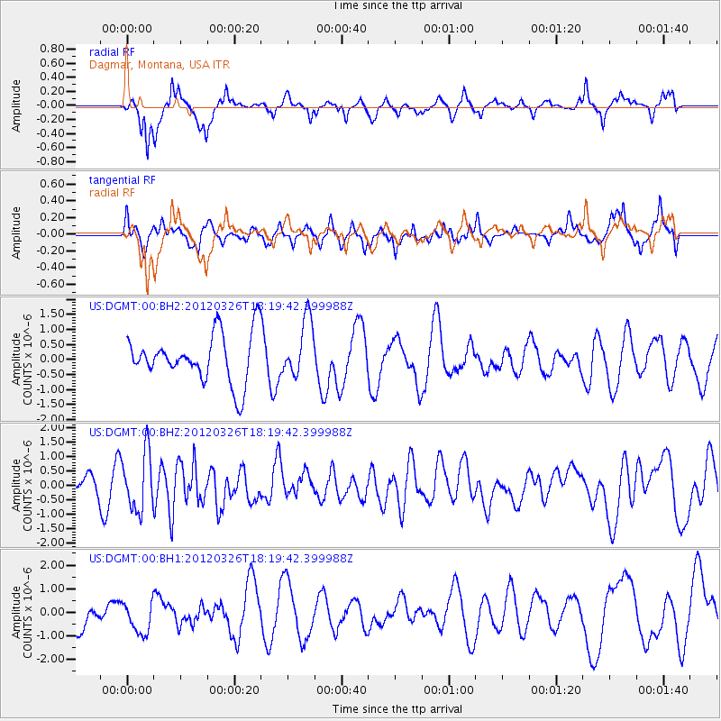
DGMT Dagmar, Montana, USA - Earthquake Result Viewer
*The percent match for this event was below the threshold and hence no stack was calculated.
| Earthquake location: |
Northern East Pacific Rise |
| Earthquake latitude/longitude: |
10.1/-104.2 |
| Earthquake time(UTC): |
2012/03/26 (086) 18:12:52 GMT |
| Earthquake Depth: |
10 km |
| Earthquake Magnitude: |
5.6 MB, 5.8 MS, 6.0 MW, 6.0 MW |
| Earthquake Catalog/Contributor: |
WHDF/NEIC |
|
| Network: |
US United States National Seismic Network |
| Station: |
DGMT Dagmar, Montana, USA |
| Lat/Lon: |
48.47 N/104.20 W |
| Elevation: |
0.0 m |
|
| Distance: |
38.3 deg |
| Az: |
359.962 deg |
| Baz: |
179.944 deg |
| Ray Param: |
$rayparam |
*The percent match for this event was below the threshold and hence was not used in the summary stack. |
|
| Radial Match: |
66.75618 % |
| Radial Bump: |
361 |
| Transverse Match: |
61.5755 % |
| Transverse Bump: |
394 |
| SOD ConfigId: |
558545 |
| Insert Time: |
2013-09-19 14:39:28.883 +0000 |
| GWidth: |
2.5 |
| Max Bumps: |
400 |
| Tol: |
0.001 |
|
Signal To Noise
| Channel | StoN | STA | LTA |
| US:DGMT:00:BHZ:20120326T18:19:42.399988Z | 2.6536777 | 9.986804E-7 | 3.7633828E-7 |
| US:DGMT:00:BH1:20120326T18:19:42.399988Z | 0.6977731 | 6.901069E-7 | 9.890133E-7 |
| US:DGMT:00:BH2:20120326T18:19:42.399988Z | 1.2254407 | 9.760583E-7 | 7.964957E-7 |
| Arrivals |
| Ps | |
| PpPs | |
| PsPs/PpSs | |


