You are here: Home > Network List > US - United States National Seismic Network Stations List
> Station HAWA Hanford, Washington, USA > Earthquake Result Viewer
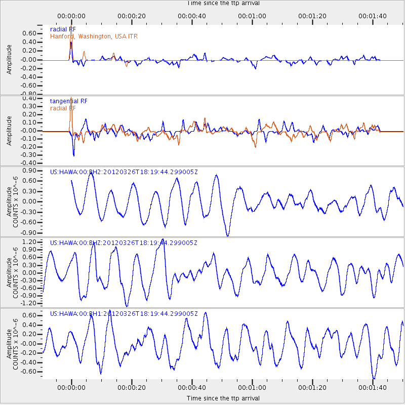
HAWA Hanford, Washington, USA - Earthquake Result Viewer
*The percent match for this event was below the threshold and hence no stack was calculated.
| Earthquake location: |
Northern East Pacific Rise |
| Earthquake latitude/longitude: |
10.1/-104.2 |
| Earthquake time(UTC): |
2012/03/26 (086) 18:12:52 GMT |
| Earthquake Depth: |
10 km |
| Earthquake Magnitude: |
5.6 MB, 5.8 MS, 6.0 MW, 6.0 MW |
| Earthquake Catalog/Contributor: |
WHDF/NEIC |
|
| Network: |
US United States National Seismic Network |
| Station: |
HAWA Hanford, Washington, USA |
| Lat/Lon: |
46.39 N/119.53 W |
| Elevation: |
364 m |
|
| Distance: |
38.5 deg |
| Az: |
342.857 deg |
| Baz: |
155.204 deg |
| Ray Param: |
$rayparam |
*The percent match for this event was below the threshold and hence was not used in the summary stack. |
|
| Radial Match: |
74.08053 % |
| Radial Bump: |
400 |
| Transverse Match: |
74.032394 % |
| Transverse Bump: |
400 |
| SOD ConfigId: |
558545 |
| Insert Time: |
2013-09-19 14:39:45.630 +0000 |
| GWidth: |
2.5 |
| Max Bumps: |
400 |
| Tol: |
0.001 |
|
Signal To Noise
| Channel | StoN | STA | LTA |
| US:HAWA:00:BHZ:20120326T18:19:44.299005Z | 1.509042 | 7.2361615E-7 | 4.7952017E-7 |
| US:HAWA:00:BH1:20120326T18:19:44.299005Z | 0.9764957 | 2.1386805E-7 | 2.1901586E-7 |
| US:HAWA:00:BH2:20120326T18:19:44.299005Z | 1.1184585 | 4.509956E-7 | 4.0322962E-7 |
| Arrivals |
| Ps | |
| PpPs | |
| PsPs/PpSs | |


