You are here: Home > Network List > CI - Caltech Regional Seismic Network Stations List
> Station LRL Laurel Mtn Radio Fac, Ridgecrest, CA, USA > Earthquake Result Viewer
LRL Laurel Mtn Radio Fac, Ridgecrest, CA, USA - Earthquake Result Viewer
| Earthquake location: |
Near Coast Of Ecuador |
| Earthquake latitude/longitude: |
-3.9/-79.2 |
| Earthquake time(UTC): |
2007/09/26 (269) 04:43:17 GMT |
| Earthquake Depth: |
100 km |
| Earthquake Magnitude: |
6.1 MB, 5.9 MW, 5.9 MW |
| Earthquake Catalog/Contributor: |
WHDF/NEIC |
|
| Network: |
CI Caltech Regional Seismic Network |
| Station: |
LRL Laurel Mtn Radio Fac, Ridgecrest, CA, USA |
| Lat/Lon: |
35.48 N/117.68 W |
| Elevation: |
1340 m |
|
| Distance: |
53.3 deg |
| Az: |
320.676 deg |
| Baz: |
129.226 deg |
| Ray Param: |
0.06590444 |
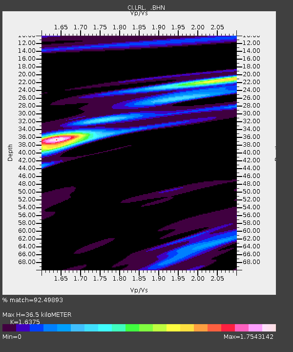
| Estimated Moho Depth: |
36.5 km |
| Estimated Crust Vp/Vs: |
1.64 |
| Assumed Crust Vp: |
6.276 km/s |
| Estimated Crust Vs: |
3.833 km/s |
| Estimated Crust Poisson's Ratio: |
0.20 |
|
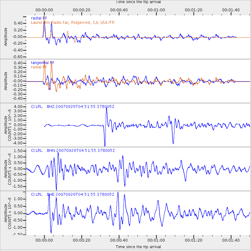
| Radial Match: |
92.49893 % |
| Radial Bump: |
295 |
| Transverse Match: |
79.56926 % |
| Transverse Bump: |
400 |
| SOD ConfigId: |
2564 |
| Insert Time: |
2010-02-25 20:40:58.947 +0000 |
| GWidth: |
2.5 |
| Max Bumps: |
400 |
| Tol: |
0.001 |
|
Signal To Noise
| Channel | StoN | STA | LTA |
| CI:LRL: :BHN:20070926T04:51:55.378005Z | 2.5788443 | 3.919084E-7 | 1.5197055E-7 |
| CI:LRL: :BHE:20070926T04:51:55.378005Z | 5.3644137 | 5.928579E-7 | 1.105168E-7 |
| CI:LRL: :BHZ:20070926T04:51:55.378005Z | 14.554386 | 1.7605548E-6 | 1.2096388E-7 |
| Arrivals |
| Ps | 3.9 SECOND |
| PpPs | 15 SECOND |
| PsPs/PpSs | 18 SECOND |


