You are here: Home > Network List > II - Global Seismograph Network (GSN - IRIS/IDA) Stations List
> Station CMLA Cha de Macela, Sao Miguel Island, Azores > Earthquake Result Viewer
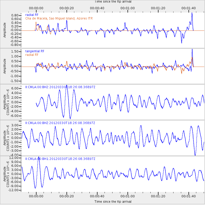
CMLA Cha de Macela, Sao Miguel Island, Azores - Earthquake Result Viewer
*The percent match for this event was below the threshold and hence no stack was calculated.
| Earthquake location: |
Near Coast Of Chiapas, Mexico |
| Earthquake latitude/longitude: |
14.4/-93.1 |
| Earthquake time(UTC): |
2012/03/30 (090) 18:16:08 GMT |
| Earthquake Depth: |
10 km |
| Earthquake Magnitude: |
5.5 MW |
| Earthquake Catalog/Contributor: |
NEIC PDE/NEIC PDE-M |
|
| Network: |
II Global Seismograph Network (GSN - IRIS/IDA) |
| Station: |
CMLA Cha de Macela, Sao Miguel Island, Azores |
| Lat/Lon: |
37.76 N/25.52 W |
| Elevation: |
429 m |
|
| Distance: |
63.6 deg |
| Az: |
54.822 deg |
| Baz: |
268.07 deg |
| Ray Param: |
$rayparam |
*The percent match for this event was below the threshold and hence was not used in the summary stack. |
|
| Radial Match: |
63.43745 % |
| Radial Bump: |
400 |
| Transverse Match: |
47.650482 % |
| Transverse Bump: |
400 |
| SOD ConfigId: |
558545 |
| Insert Time: |
2013-09-19 14:47:04.852 +0000 |
| GWidth: |
2.5 |
| Max Bumps: |
400 |
| Tol: |
0.001 |
|
Signal To Noise
| Channel | StoN | STA | LTA |
| II:CMLA:00:BHZ:20120330T18:26:08.36897Z | 0.74606496 | 8.048252E-7 | 1.0787602E-6 |
| II:CMLA:00:BH1:20120330T18:26:08.36897Z | 2.532917 | 8.286738E-6 | 3.2716187E-6 |
| II:CMLA:00:BH2:20120330T18:26:08.36897Z | 0.30654714 | 1.0169657E-6 | 3.3174856E-6 |
| Arrivals |
| Ps | |
| PpPs | |
| PsPs/PpSs | |


