You are here: Home > Network List > US - United States National Seismic Network Stations List
> Station DGMT Dagmar, Montana, USA > Earthquake Result Viewer
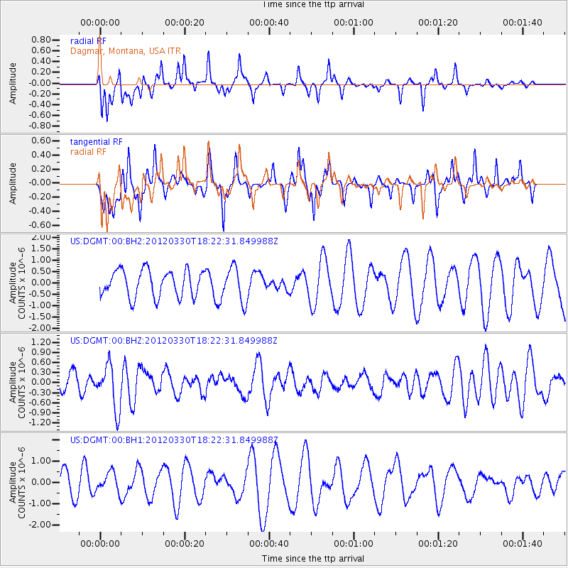
DGMT Dagmar, Montana, USA - Earthquake Result Viewer
*The percent match for this event was below the threshold and hence no stack was calculated.
| Earthquake location: |
Near Coast Of Chiapas, Mexico |
| Earthquake latitude/longitude: |
14.4/-93.1 |
| Earthquake time(UTC): |
2012/03/30 (090) 18:16:08 GMT |
| Earthquake Depth: |
10 km |
| Earthquake Magnitude: |
5.5 MW |
| Earthquake Catalog/Contributor: |
NEIC PDE/NEIC PDE-M |
|
| Network: |
US United States National Seismic Network |
| Station: |
DGMT Dagmar, Montana, USA |
| Lat/Lon: |
48.47 N/104.20 W |
| Elevation: |
0.0 m |
|
| Distance: |
35.2 deg |
| Az: |
347.125 deg |
| Baz: |
161.067 deg |
| Ray Param: |
$rayparam |
*The percent match for this event was below the threshold and hence was not used in the summary stack. |
|
| Radial Match: |
56.994423 % |
| Radial Bump: |
381 |
| Transverse Match: |
52.83625 % |
| Transverse Bump: |
297 |
| SOD ConfigId: |
558545 |
| Insert Time: |
2013-09-19 14:47:47.408 +0000 |
| GWidth: |
2.5 |
| Max Bumps: |
400 |
| Tol: |
0.001 |
|
Signal To Noise
| Channel | StoN | STA | LTA |
| US:DGMT:00:BHZ:20120330T18:22:31.849988Z | 3.1801 | 6.8396577E-7 | 2.1507681E-7 |
| US:DGMT:00:BH1:20120330T18:22:31.849988Z | 0.5828209 | 4.611502E-7 | 7.912383E-7 |
| US:DGMT:00:BH2:20120330T18:22:31.849988Z | 1.3271382 | 7.737778E-7 | 5.830424E-7 |
| Arrivals |
| Ps | |
| PpPs | |
| PsPs/PpSs | |


