You are here: Home > Network List > IU - Global Seismograph Network (GSN - IRIS/USGS) Stations List
> Station XMAS Kiritimati Island, Republic of Kiribati > Earthquake Result Viewer
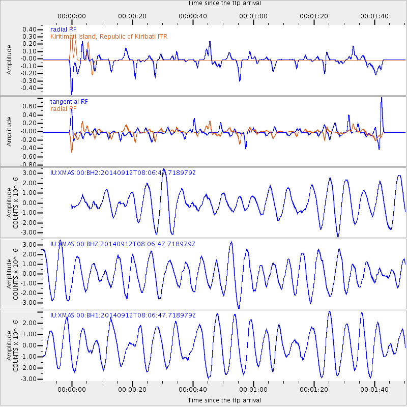
XMAS Kiritimati Island, Republic of Kiribati - Earthquake Result Viewer
*The percent match for this event was below the threshold and hence no stack was calculated.
| Earthquake location: |
Near North Coast Of Irian Jaya |
| Earthquake latitude/longitude: |
-2.3/139.1 |
| Earthquake time(UTC): |
2014/09/12 (255) 07:56:51 GMT |
| Earthquake Depth: |
37 km |
| Earthquake Magnitude: |
5.0 mb |
| Earthquake Catalog/Contributor: |
ISC/ISC |
|
| Network: |
IU Global Seismograph Network (GSN - IRIS/USGS) |
| Station: |
XMAS Kiritimati Island, Republic of Kiribati |
| Lat/Lon: |
2.04 N/157.45 W |
| Elevation: |
20 m |
|
| Distance: |
63.6 deg |
| Az: |
86.614 deg |
| Baz: |
266.485 deg |
| Ray Param: |
$rayparam |
*The percent match for this event was below the threshold and hence was not used in the summary stack. |
|
| Radial Match: |
61.164455 % |
| Radial Bump: |
400 |
| Transverse Match: |
59.62688 % |
| Transverse Bump: |
400 |
| SOD ConfigId: |
3390531 |
| Insert Time: |
2019-04-14 00:17:28.659 +0000 |
| GWidth: |
2.5 |
| Max Bumps: |
400 |
| Tol: |
0.001 |
|
Signal To Noise
| Channel | StoN | STA | LTA |
| IU:XMAS:00:BHZ:20140912T08:06:47.718979Z | 1.2250166 | 1.4343349E-6 | 1.1708697E-6 |
| IU:XMAS:00:BH1:20140912T08:06:47.718979Z | 0.7770723 | 1.3768297E-6 | 1.7718168E-6 |
| IU:XMAS:00:BH2:20140912T08:06:47.718979Z | 2.9253697 | 2.2967347E-6 | 7.851092E-7 |
| Arrivals |
| Ps | |
| PpPs | |
| PsPs/PpSs | |


