You are here: Home > Network List > II - Global Seismograph Network (GSN - IRIS/IDA) Stations List
> Station EFI Mount Kent, East Falkland Island > Earthquake Result Viewer
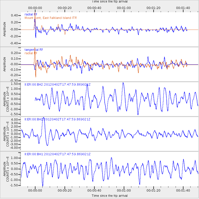
EFI Mount Kent, East Falkland Island - Earthquake Result Viewer
*The percent match for this event was below the threshold and hence no stack was calculated.
| Earthquake location: |
Near Coast Of Guerrero, Mexico |
| Earthquake latitude/longitude: |
16.4/-98.3 |
| Earthquake time(UTC): |
2012/04/02 (093) 17:36:42 GMT |
| Earthquake Depth: |
9.0 km |
| Earthquake Magnitude: |
5.8 MB, 5.9 MS, 6.0 MW, 6.0 MW |
| Earthquake Catalog/Contributor: |
WHDF/NEIC |
|
| Network: |
II Global Seismograph Network (GSN - IRIS/IDA) |
| Station: |
EFI Mount Kent, East Falkland Island |
| Lat/Lon: |
51.68 S/58.06 W |
| Elevation: |
110 m |
|
| Distance: |
76.3 deg |
| Az: |
155.537 deg |
| Baz: |
320.332 deg |
| Ray Param: |
$rayparam |
*The percent match for this event was below the threshold and hence was not used in the summary stack. |
|
| Radial Match: |
51.912106 % |
| Radial Bump: |
400 |
| Transverse Match: |
63.54591 % |
| Transverse Bump: |
400 |
| SOD ConfigId: |
558545 |
| Insert Time: |
2013-09-19 14:55:19.956 +0000 |
| GWidth: |
2.5 |
| Max Bumps: |
400 |
| Tol: |
0.001 |
|
Signal To Noise
| Channel | StoN | STA | LTA |
| II:EFI:00:BHZ:20120402T17:47:59.869021Z | 2.1874971 | 1.1994466E-6 | 5.483192E-7 |
| II:EFI:00:BH1:20120402T17:47:59.869021Z | 0.6669993 | 3.4035898E-7 | 5.102838E-7 |
| II:EFI:00:BH2:20120402T17:47:59.869021Z | 1.0883175 | 5.276602E-7 | 4.848403E-7 |
| Arrivals |
| Ps | |
| PpPs | |
| PsPs/PpSs | |


