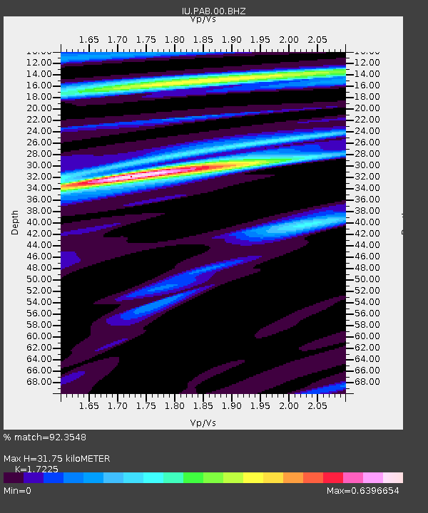
PAB San Pablo, Spain - Earthquake Result Viewer

Earthquake location: Near Coast Of Guerrero, Mexico
Earthquake latitude/longitude: 16.4/-98.3
Earthquake time(UTC): 2012/04/02 (093) 17:36:42 GMT
Earthquake Depth: 9.0 km
Earthquake Magnitude: 5.8 MB, 5.9 MS, 6.0 MW, 6.0 MW
Earthquake Catalog/Contributor: WHDF/NEIC
Network: IU Global Seismograph Network (GSN - IRIS/USGS)
Station: PAB San Pablo, Spain
Lat/Lon: 39.54 N/4.35 W
Elevation: 950 m
Distance: 82.7 deg
Az: 51.044 deg
Baz: 285.135 deg
Ray Param: 0.046686508
Estimated Moho Depth: 31.75 km
Estimated Crust Vp/Vs: 1.72
Assumed Crust Vp: 6.276 km/s
Estimated Crust Vs: 3.643 km/s
Estimated Crust Poisson's Ratio: 0.25
Radial Match: 92.3548 %
Radial Bump: 301
Transverse Match: 80.006584 %
Transverse Bump: 400
SOD ConfigId: 558545
Insert Time: 2013-09-19 14:55:49.456 +0000
GWidth: 2.5
Max Bumps: 400
Tol: 0.001

Signal To Noise

ChannelStoNSTALTA
IU:PAB:00:BHZ:20120402T17:48:34.669009Z7.883837.461247E-79.463988E-8
IU:PAB:00:BH1:20120402T17:48:34.669009Z1.19601958.901745E-87.4428094E-8
IU:PAB:00:BH2:20120402T17:48:34.669009Z2.61895372.3064877E-78.806905E-8
Arrivals
Ps3.8 SECOND
PpPs13 SECOND
PsPs/PpSs17 SECOND