You are here: Home > Network List > US - United States National Seismic Network Stations List
> Station BMO Blue Mountains Array (Baker), Oregon, USA > Earthquake Result Viewer
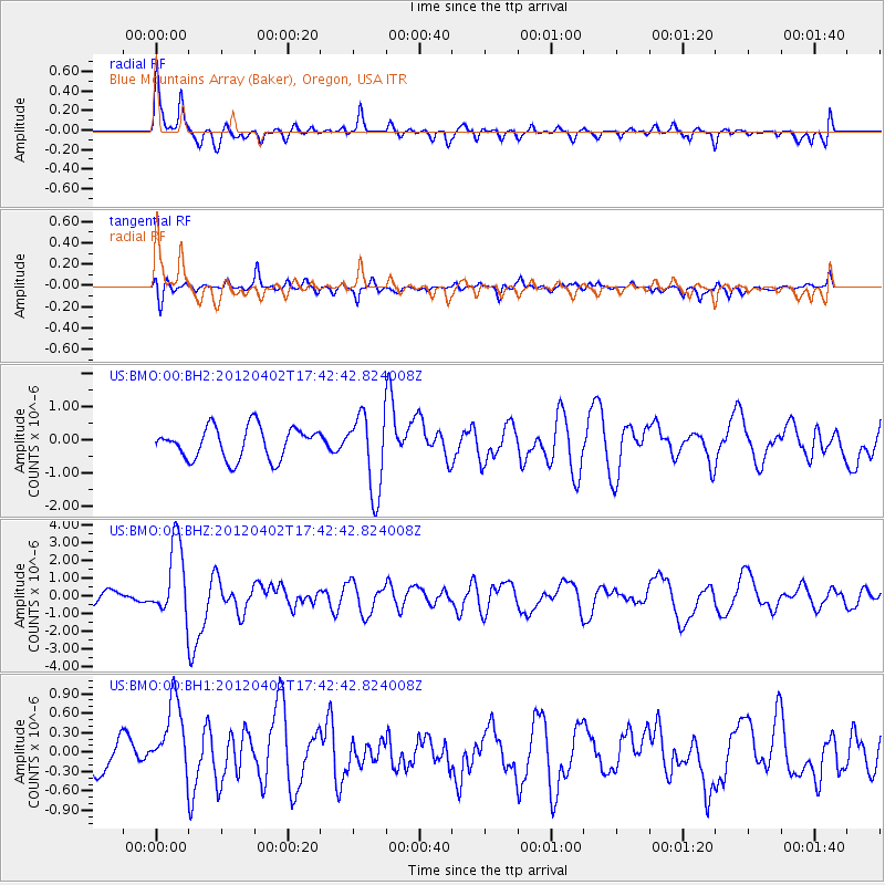
BMO Blue Mountains Array (Baker), Oregon, USA - Earthquake Result Viewer
*The percent match for this event was below the threshold and hence no stack was calculated.
| Earthquake location: |
Near Coast Of Guerrero, Mexico |
| Earthquake latitude/longitude: |
16.4/-98.3 |
| Earthquake time(UTC): |
2012/04/02 (093) 17:36:42 GMT |
| Earthquake Depth: |
9.0 km |
| Earthquake Magnitude: |
5.8 MB, 5.9 MS, 6.0 MW, 6.0 MW |
| Earthquake Catalog/Contributor: |
WHDF/NEIC |
|
| Network: |
US United States National Seismic Network |
| Station: |
BMO Blue Mountains Array (Baker), Oregon, USA |
| Lat/Lon: |
44.85 N/117.31 W |
| Elevation: |
1189 m |
|
| Distance: |
32.6 deg |
| Az: |
334.531 deg |
| Baz: |
144.531 deg |
| Ray Param: |
$rayparam |
*The percent match for this event was below the threshold and hence was not used in the summary stack. |
|
| Radial Match: |
73.21363 % |
| Radial Bump: |
396 |
| Transverse Match: |
62.3869 % |
| Transverse Bump: |
400 |
| SOD ConfigId: |
558545 |
| Insert Time: |
2013-09-19 14:56:13.378 +0000 |
| GWidth: |
2.5 |
| Max Bumps: |
400 |
| Tol: |
0.001 |
|
Signal To Noise
| Channel | StoN | STA | LTA |
| US:BMO:00:BHZ:20120402T17:42:42.824008Z | 5.6701035 | 2.1079777E-6 | 3.7177057E-7 |
| US:BMO:00:BH1:20120402T17:42:42.824008Z | 1.7529955 | 6.4612954E-7 | 3.6858597E-7 |
| US:BMO:00:BH2:20120402T17:42:42.824008Z | 2.4415038 | 1.1600459E-6 | 4.7513583E-7 |
| Arrivals |
| Ps | |
| PpPs | |
| PsPs/PpSs | |


