You are here: Home > Network List > US - United States National Seismic Network Stations List
> Station DGMT Dagmar, Montana, USA > Earthquake Result Viewer
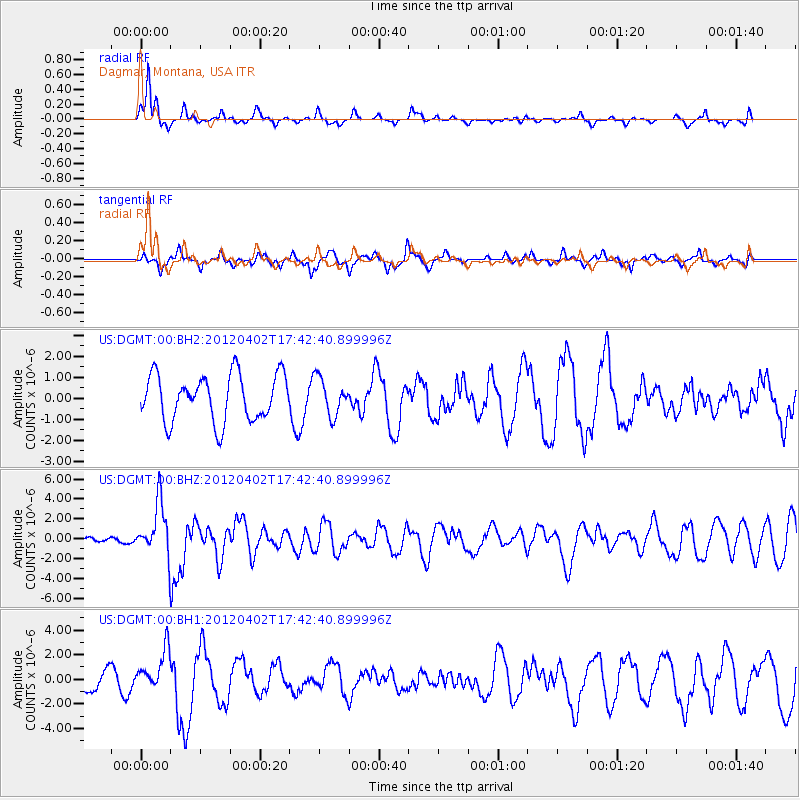
DGMT Dagmar, Montana, USA - Earthquake Result Viewer
*The percent match for this event was below the threshold and hence no stack was calculated.
| Earthquake location: |
Near Coast Of Guerrero, Mexico |
| Earthquake latitude/longitude: |
16.4/-98.3 |
| Earthquake time(UTC): |
2012/04/02 (093) 17:36:42 GMT |
| Earthquake Depth: |
9.0 km |
| Earthquake Magnitude: |
5.8 MB, 5.9 MS, 6.0 MW, 6.0 MW |
| Earthquake Catalog/Contributor: |
WHDF/NEIC |
|
| Network: |
US United States National Seismic Network |
| Station: |
DGMT Dagmar, Montana, USA |
| Lat/Lon: |
48.47 N/104.20 W |
| Elevation: |
0.0 m |
|
| Distance: |
32.3 deg |
| Az: |
352.681 deg |
| Baz: |
169.412 deg |
| Ray Param: |
$rayparam |
*The percent match for this event was below the threshold and hence was not used in the summary stack. |
|
| Radial Match: |
85.60937 % |
| Radial Bump: |
284 |
| Transverse Match: |
56.895523 % |
| Transverse Bump: |
377 |
| SOD ConfigId: |
558545 |
| Insert Time: |
2013-09-19 14:56:18.243 +0000 |
| GWidth: |
2.5 |
| Max Bumps: |
400 |
| Tol: |
0.001 |
|
Signal To Noise
| Channel | StoN | STA | LTA |
| US:DGMT:00:BHZ:20120402T17:42:40.899996Z | 10.157117 | 2.6459636E-6 | 2.6050338E-7 |
| US:DGMT:00:BH1:20120402T17:42:40.899996Z | 2.2037191 | 1.6480132E-6 | 7.478327E-7 |
| US:DGMT:00:BH2:20120402T17:42:40.899996Z | 0.7969307 | 8.795747E-7 | 1.103703E-6 |
| Arrivals |
| Ps | |
| PpPs | |
| PsPs/PpSs | |


