You are here: Home > Network List > US - United States National Seismic Network Stations List
> Station HAWA Hanford, Washington, USA > Earthquake Result Viewer
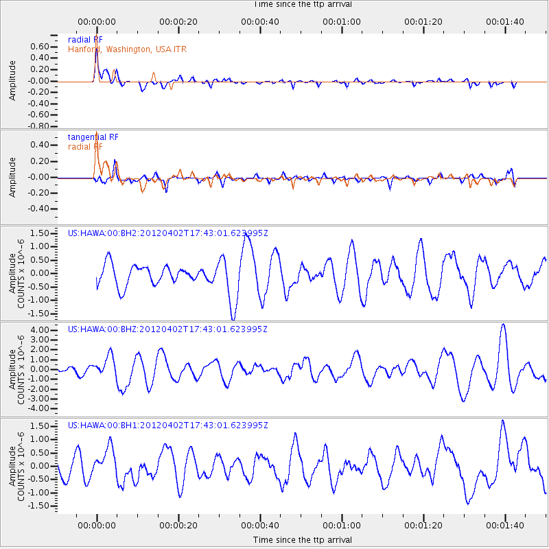
HAWA Hanford, Washington, USA - Earthquake Result Viewer
*The percent match for this event was below the threshold and hence no stack was calculated.
| Earthquake location: |
Near Coast Of Guerrero, Mexico |
| Earthquake latitude/longitude: |
16.4/-98.3 |
| Earthquake time(UTC): |
2012/04/02 (093) 17:36:42 GMT |
| Earthquake Depth: |
9.0 km |
| Earthquake Magnitude: |
5.8 MB, 5.9 MS, 6.0 MW, 6.0 MW |
| Earthquake Catalog/Contributor: |
WHDF/NEIC |
|
| Network: |
US United States National Seismic Network |
| Station: |
HAWA Hanford, Washington, USA |
| Lat/Lon: |
46.39 N/119.53 W |
| Elevation: |
364 m |
|
| Distance: |
34.7 deg |
| Az: |
333.922 deg |
| Baz: |
142.437 deg |
| Ray Param: |
$rayparam |
*The percent match for this event was below the threshold and hence was not used in the summary stack. |
|
| Radial Match: |
66.64542 % |
| Radial Bump: |
393 |
| Transverse Match: |
45.676468 % |
| Transverse Bump: |
360 |
| SOD ConfigId: |
558545 |
| Insert Time: |
2013-09-19 14:56:31.404 +0000 |
| GWidth: |
2.5 |
| Max Bumps: |
400 |
| Tol: |
0.001 |
|
Signal To Noise
| Channel | StoN | STA | LTA |
| US:HAWA:00:BHZ:20120402T17:43:01.623995Z | 2.0987413 | 1.0638967E-6 | 5.0692125E-7 |
| US:HAWA:00:BH1:20120402T17:43:01.623995Z | 1.6191497 | 5.5907907E-7 | 3.4529177E-7 |
| US:HAWA:00:BH2:20120402T17:43:01.623995Z | 2.5769525 | 9.345562E-7 | 3.6265948E-7 |
| Arrivals |
| Ps | |
| PpPs | |
| PsPs/PpSs | |


