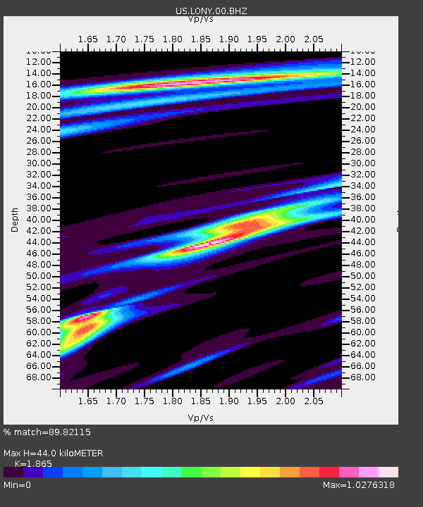
LONY Lake Ozonia, New York, USA - Earthquake Result Viewer
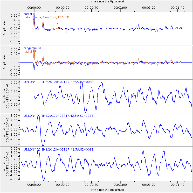
Earthquake location: Near Coast Of Guerrero, Mexico
Earthquake latitude/longitude: 16.4/-98.3
Earthquake time(UTC): 2012/04/02 (093) 17:36:42 GMT
Earthquake Depth: 9.0 km
Earthquake Magnitude: 5.8 MB, 5.9 MS, 6.0 MW, 6.0 MW
Earthquake Catalog/Contributor: WHDF/NEIC
Network: US United States National Seismic Network
Station: LONY Lake Ozonia, New York, USA
Lat/Lon: 44.62 N/74.58 W
Elevation: 440 m
Distance: 34.5 deg
Az: 30.471 deg
Baz: 222.967 deg
Ray Param: 0.07769802
Estimated Moho Depth: 44.0 km
Estimated Crust Vp/Vs: 1.87
Assumed Crust Vp: 6.419 km/s
Estimated Crust Vs: 3.442 km/s
Estimated Crust Poisson's Ratio: 0.30
Radial Match: 89.82115 %
Radial Bump: 287
Transverse Match: 65.26165 %
Transverse Bump: 400
SOD ConfigId: 558545
Insert Time: 2013-09-19 14:56:41.017 +0000
GWidth: 2.5
Max Bumps: 400
Tol: 0.001

Signal To Noise

ChannelStoNSTALTA
US:LONY:00:BHZ:20120402T17:42:59.824008Z5.74522451.6900341E-62.9416327E-7
US:LONY:00:BH1:20120402T17:42:59.824008Z4.5293969.690889E-72.1395543E-7
US:LONY:00:BH2:20120402T17:42:59.824008Z2.07791645.4400425E-72.6180274E-7
Arrivals
Ps6.4 SECOND
PpPs18 SECOND
PsPs/PpSs25 SECOND