You are here: Home > Network List > US - United States National Seismic Network Stations List
> Station CBKS Cedar Bluff, Kansas, USA > Earthquake Result Viewer
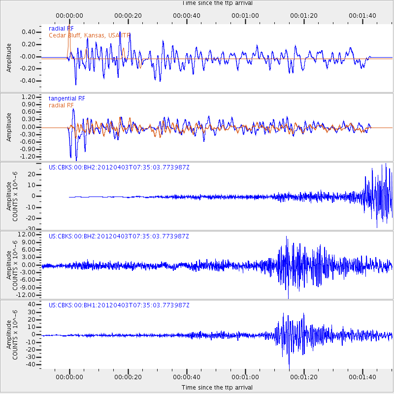
CBKS Cedar Bluff, Kansas, USA - Earthquake Result Viewer
*The percent match for this event was below the threshold and hence no stack was calculated.
| Earthquake location: |
Northern Chile |
| Earthquake latitude/longitude: |
-19.6/-69.1 |
| Earthquake time(UTC): |
2012/04/03 (094) 07:25:08 GMT |
| Earthquake Depth: |
117 km |
| Earthquake Magnitude: |
5.5 ML, 5.2 MB |
| Earthquake Catalog/Contributor: |
WHDF/NEIC |
|
| Network: |
US United States National Seismic Network |
| Station: |
CBKS Cedar Bluff, Kansas, USA |
| Lat/Lon: |
38.81 N/99.74 W |
| Elevation: |
677 m |
|
| Distance: |
64.9 deg |
| Az: |
333.902 deg |
| Baz: |
147.945 deg |
| Ray Param: |
$rayparam |
*The percent match for this event was below the threshold and hence was not used in the summary stack. |
|
| Radial Match: |
37.521034 % |
| Radial Bump: |
400 |
| Transverse Match: |
52.367096 % |
| Transverse Bump: |
400 |
| SOD ConfigId: |
558545 |
| Insert Time: |
2013-09-19 14:59:02.703 +0000 |
| GWidth: |
2.5 |
| Max Bumps: |
400 |
| Tol: |
0.001 |
|
Signal To Noise
| Channel | StoN | STA | LTA |
| US:CBKS:00:BHZ:20120403T07:35:03.773987Z | 2.7821567 | 6.8850426E-7 | 2.474714E-7 |
| US:CBKS:00:BH1:20120403T07:35:03.773987Z | 1.3588575 | 4.1293833E-7 | 3.0388642E-7 |
| US:CBKS:00:BH2:20120403T07:35:03.773987Z | 1.9231244 | 4.1611014E-7 | 2.1637193E-7 |
| Arrivals |
| Ps | |
| PpPs | |
| PsPs/PpSs | |


