You are here: Home > Network List > US - United States National Seismic Network Stations List
> Station MSO Missoula, Montana, USA > Earthquake Result Viewer
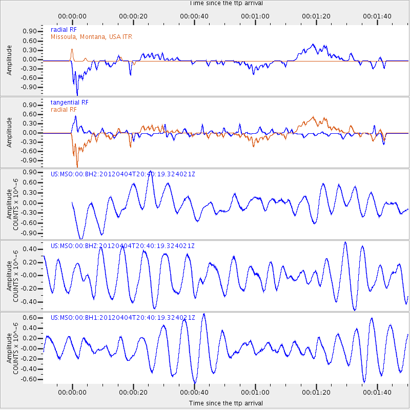
MSO Missoula, Montana, USA - Earthquake Result Viewer
*The percent match for this event was below the threshold and hence no stack was calculated.
| Earthquake location: |
New Ireland Region, P.N.G. |
| Earthquake latitude/longitude: |
-3.8/152.2 |
| Earthquake time(UTC): |
2012/04/04 (095) 20:27:26 GMT |
| Earthquake Depth: |
10 km |
| Earthquake Magnitude: |
5.5 MB |
| Earthquake Catalog/Contributor: |
NEIC PDE/NEIC PDE-M |
|
| Network: |
US United States National Seismic Network |
| Station: |
MSO Missoula, Montana, USA |
| Lat/Lon: |
46.83 N/113.94 W |
| Elevation: |
1264 m |
|
| Distance: |
95.4 deg |
| Az: |
43.482 deg |
| Baz: |
270.212 deg |
| Ray Param: |
$rayparam |
*The percent match for this event was below the threshold and hence was not used in the summary stack. |
|
| Radial Match: |
59.332764 % |
| Radial Bump: |
400 |
| Transverse Match: |
72.85462 % |
| Transverse Bump: |
400 |
| SOD ConfigId: |
558545 |
| Insert Time: |
2013-09-19 15:03:39.244 +0000 |
| GWidth: |
2.5 |
| Max Bumps: |
400 |
| Tol: |
0.001 |
|
Signal To Noise
| Channel | StoN | STA | LTA |
| US:MSO:00:BHZ:20120404T20:40:19.324021Z | 0.5647124 | 1.2387484E-7 | 2.1935918E-7 |
| US:MSO:00:BH1:20120404T20:40:19.324021Z | 0.8494172 | 1.57648E-7 | 1.855955E-7 |
| US:MSO:00:BH2:20120404T20:40:19.324021Z | 1.1848149 | 5.1056E-7 | 4.3091964E-7 |
| Arrivals |
| Ps | |
| PpPs | |
| PsPs/PpSs | |


