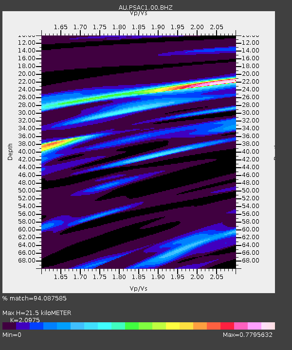
PSAC1 Pilbara Seismic Array Element C1 - Earthquake Result Viewer

Earthquake location: Off W Coast Of Northern Sumatra
Earthquake latitude/longitude: 2.3/93.1
Earthquake time(UTC): 2012/04/11 (102) 08:38:36 GMT
Earthquake Depth: 20 km
Earthquake Magnitude: 7.4 MB, 8.5 MS, 8.6 MW, 8.6 MW
Earthquake Catalog/Contributor: WHDF/NEIC
Network: AU Australian Seismological Centre
Station: PSAC1 Pilbara Seismic Array Element C1
Lat/Lon: 21.53 S/119.81 E
Elevation: 303 m
Distance: 35.3 deg
Az: 133.538 deg
Baz: 308.925 deg
Ray Param: 0.0772671
Estimated Moho Depth: 21.5 km
Estimated Crust Vp/Vs: 2.10
Assumed Crust Vp: 6.464 km/s
Estimated Crust Vs: 3.082 km/s
Estimated Crust Poisson's Ratio: 0.35
Radial Match: 94.087585 %
Radial Bump: 269
Transverse Match: 85.87983 %
Transverse Bump: 400
SOD ConfigId: 558545
Insert Time: 2013-09-19 15:15:54.458 +0000
GWidth: 2.5
Max Bumps: 400
Tol: 0.001

Signal To Noise

ChannelStoNSTALTA
AU:PSAC1:00:BHZ:20120411T08:44:59.693999Z8.9774651.3801511E-51.5373506E-6
AU:PSAC1:00:BH1:20120411T08:44:59.693999Z9.5982825.233507E-65.452546E-7
AU:PSAC1:00:BH2:20120411T08:44:59.693999Z8.8501083.7374061E-64.2230064E-7
Arrivals
Ps3.9 SECOND
PpPs9.7 SECOND
PsPs/PpSs14 SECOND