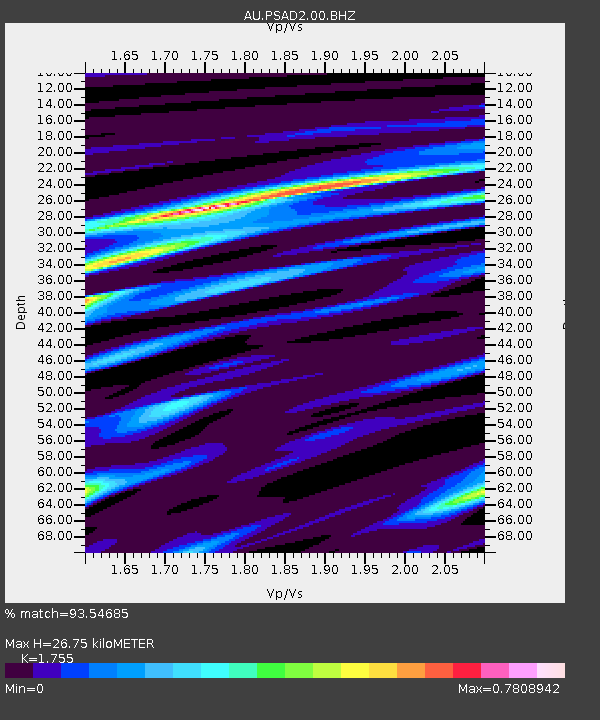
PSAD2 Pilbara Seismic Array Element D2 - Earthquake Result Viewer

Earthquake location: Off W Coast Of Northern Sumatra
Earthquake latitude/longitude: 2.3/93.1
Earthquake time(UTC): 2012/04/11 (102) 08:38:36 GMT
Earthquake Depth: 20 km
Earthquake Magnitude: 7.4 MB, 8.5 MS, 8.6 MW, 8.6 MW
Earthquake Catalog/Contributor: WHDF/NEIC
Network: AU Australian Seismological Centre
Station: PSAD2 Pilbara Seismic Array Element D2
Lat/Lon: 21.62 S/119.96 E
Elevation: 366 m
Distance: 35.5 deg
Az: 133.496 deg
Baz: 308.834 deg
Ray Param: 0.07717996
Estimated Moho Depth: 26.75 km
Estimated Crust Vp/Vs: 1.75
Assumed Crust Vp: 6.464 km/s
Estimated Crust Vs: 3.683 km/s
Estimated Crust Poisson's Ratio: 0.26
Radial Match: 93.54685 %
Radial Bump: 211
Transverse Match: 82.303246 %
Transverse Bump: 303
SOD ConfigId: 558545
Insert Time: 2013-09-19 15:16:01.912 +0000
GWidth: 2.5
Max Bumps: 400
Tol: 0.001

Signal To Noise

ChannelStoNSTALTA
AU:PSAD2:00:BHZ:20120411T08:45:01.093993Z8.4725241.321057E-51.5592249E-6
AU:PSAD2:00:BH1:20120411T08:45:01.093993Z9.3499826.435696E-66.8831105E-7
AU:PSAD2:00:BH2:20120411T08:45:01.093993Z9.7521157.3903598E-67.5782117E-7
Arrivals
Ps3.4 SECOND
PpPs11 SECOND
PsPs/PpSs14 SECOND