You are here: Home > Network List > II - Global Seismograph Network (GSN - IRIS/IDA) Stations List
> Station WRAB Tennant Creek, NT, Australia > Earthquake Result Viewer
WRAB Tennant Creek, NT, Australia - Earthquake Result Viewer
| Earthquake location: |
Off W Coast Of Northern Sumatra |
| Earthquake latitude/longitude: |
2.3/93.1 |
| Earthquake time(UTC): |
2012/04/11 (102) 08:38:36 GMT |
| Earthquake Depth: |
20 km |
| Earthquake Magnitude: |
7.4 MB, 8.5 MS, 8.6 MW, 8.6 MW |
| Earthquake Catalog/Contributor: |
WHDF/NEIC |
|
| Network: |
II Global Seismograph Network (GSN - IRIS/IDA) |
| Station: |
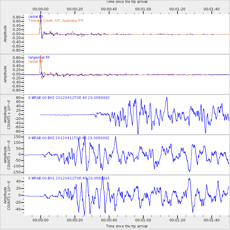
WRAB Tennant Creek, NT, Australia |
| Lat/Lon: |
19.93 S/134.36 E |
| Elevation: |
366 m |
|
| Distance: |
46.2 deg |
| Az: |
120.596 deg |
| Baz: |
293.91 deg |
| Ray Param: |
0.07078856 |
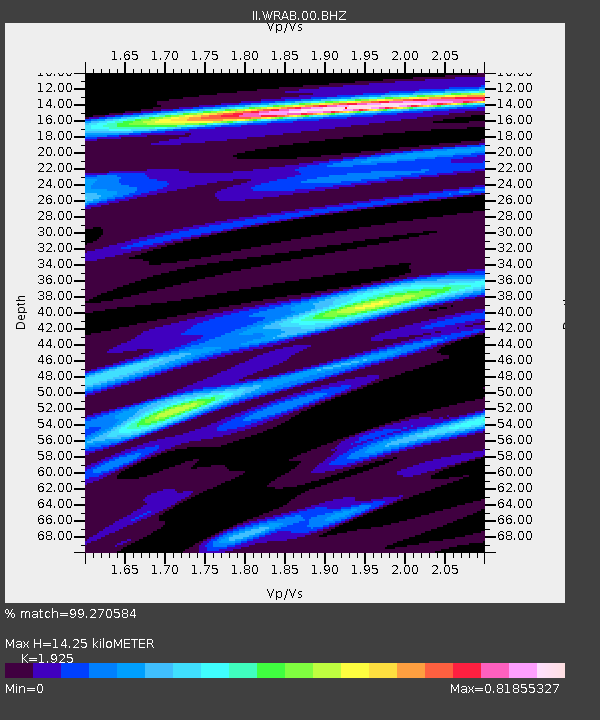
| Estimated Moho Depth: |
14.25 km |
| Estimated Crust Vp/Vs: |
1.92 |
| Assumed Crust Vp: |
6.642 km/s |
| Estimated Crust Vs: |
3.45 km/s |
| Estimated Crust Poisson's Ratio: |
0.32 |
|
| Radial Match: |
99.270584 % |
| Radial Bump: |
196 |
| Transverse Match: |
95.56345 % |
| Transverse Bump: |
400 |
| SOD ConfigId: |
558545 |
| Insert Time: |
2013-09-19 15:16:37.378 +0000 |
| GWidth: |
2.5 |
| Max Bumps: |
400 |
| Tol: |
0.001 |
|
Signal To Noise
| Channel | StoN | STA | LTA |
| II:WRAB:00:BHZ:20120411T08:46:29.068999Z | 19.35822 | 1.05937315E-5 | 5.4724717E-7 |
| II:WRAB:00:BH1:20120411T08:46:29.068999Z | 15.441975 | 3.1215648E-6 | 2.0214804E-7 |
| II:WRAB:00:BH2:20120411T08:46:29.068999Z | 15.578116 | 6.2445856E-6 | 4.0085627E-7 |
| Arrivals |
| Ps | 2.1 SECOND |
| PpPs | 5.9 SECOND |
| PsPs/PpSs | 8.0 SECOND |


