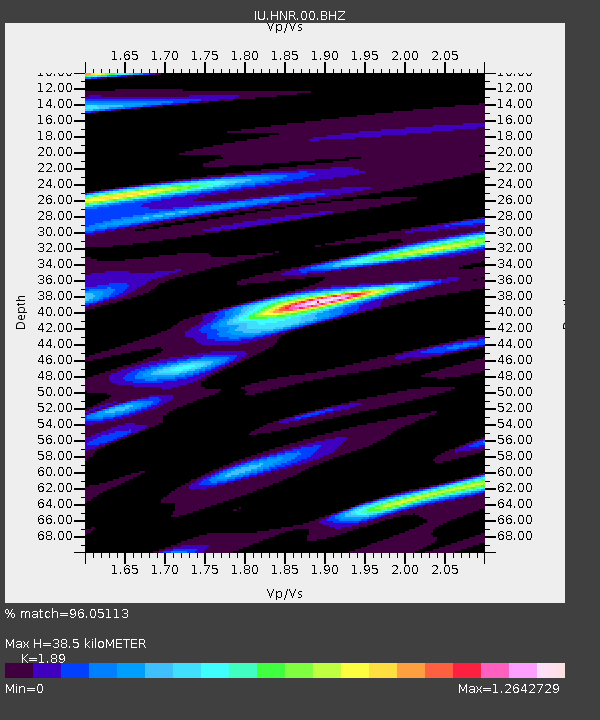
HNR Honiara, Solomon Islands - Earthquake Result Viewer

Earthquake location: Off W Coast Of Northern Sumatra
Earthquake latitude/longitude: 2.3/93.1
Earthquake time(UTC): 2012/04/11 (102) 08:38:36 GMT
Earthquake Depth: 20 km
Earthquake Magnitude: 7.4 MB, 8.5 MS, 8.6 MW, 8.6 MW
Earthquake Catalog/Contributor: WHDF/NEIC
Network: IU Global Seismograph Network (GSN - IRIS/USGS)
Station: HNR Honiara, Solomon Islands
Lat/Lon: 9.44 S/159.95 E
Elevation: 100 m
Distance: 67.6 deg
Az: 101.123 deg
Baz: 276.438 deg
Ray Param: 0.056805402
Estimated Moho Depth: 38.5 km
Estimated Crust Vp/Vs: 1.89
Assumed Crust Vp: 6.183 km/s
Estimated Crust Vs: 3.271 km/s
Estimated Crust Poisson's Ratio: 0.31
Radial Match: 96.05113 %
Radial Bump: 400
Transverse Match: 97.560234 %
Transverse Bump: 330
SOD ConfigId: 558545
Insert Time: 2013-09-19 15:16:49.909 +0000
GWidth: 2.5
Max Bumps: 400
Tol: 0.001

Signal To Noise

ChannelStoNSTALTA
IU:HNR:00:BHZ:20120411T08:49:01.019011Z11.4776454.711731E-64.1051374E-7
IU:HNR:00:BH1:20120411T08:49:01.019011Z4.90964131.8305003E-63.7283792E-7
IU:HNR:00:BH2:20120411T08:49:01.019011Z5.4991591.8287734E-63.3255512E-7
Arrivals
Ps5.7 SECOND
PpPs17 SECOND
PsPs/PpSs23 SECOND