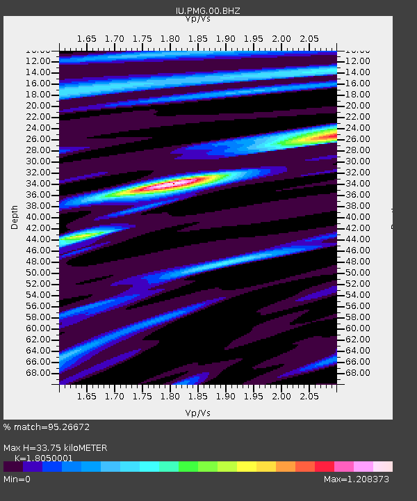
PMG Port Moresby, New Guinea - Earthquake Result Viewer
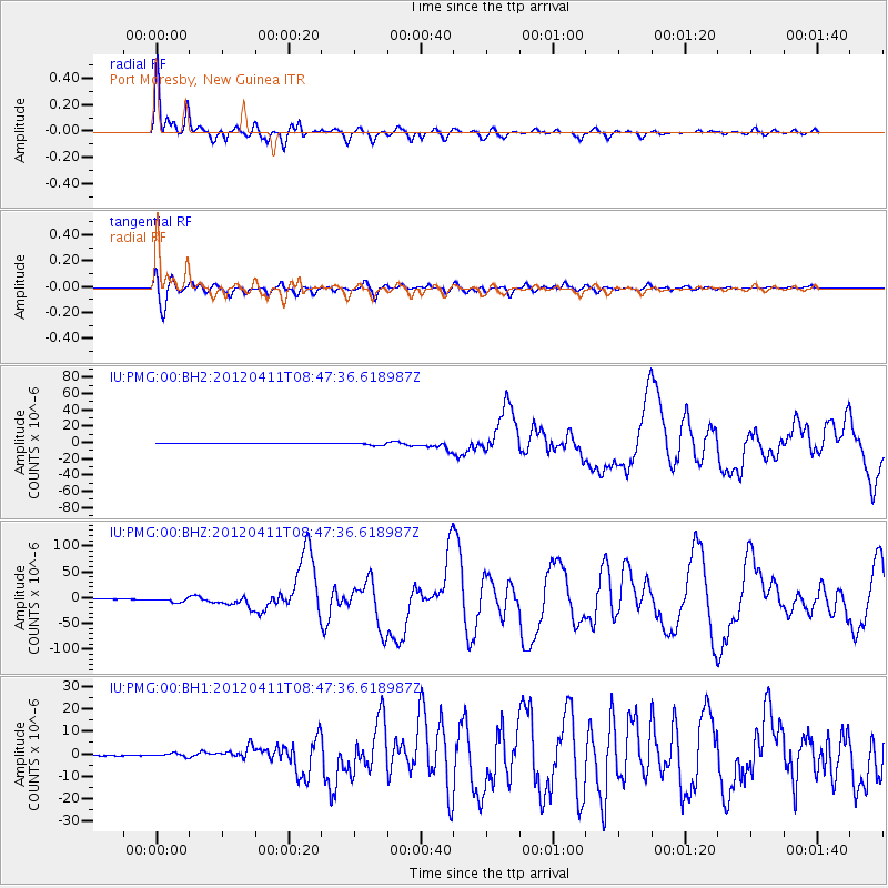
Earthquake location: Off W Coast Of Northern Sumatra
Earthquake latitude/longitude: 2.3/93.1
Earthquake time(UTC): 2012/04/11 (102) 08:38:36 GMT
Earthquake Depth: 20 km
Earthquake Magnitude: 7.4 MB, 8.5 MS, 8.6 MW, 8.6 MW
Earthquake Catalog/Contributor: WHDF/NEIC
Network: IU Global Seismograph Network (GSN - IRIS/USGS)
Station: PMG Port Moresby, New Guinea
Lat/Lon: 9.40 S/147.16 E
Elevation: 90 m
Distance: 55.1 deg
Az: 103.07 deg
Baz: 279.464 deg
Ray Param: 0.06496817
Estimated Moho Depth: 33.75 km
Estimated Crust Vp/Vs: 1.81
Assumed Crust Vp: 6.122 km/s
Estimated Crust Vs: 3.392 km/s
Estimated Crust Poisson's Ratio: 0.28
Radial Match: 95.26672 %
Radial Bump: 400
Transverse Match: 87.56374 %
Transverse Bump: 400
SOD ConfigId: 558545
Insert Time: 2013-09-19 15:17:21.419 +0000
GWidth: 2.5
Max Bumps: 400
Tol: 0.001

Signal To Noise

ChannelStoNSTALTA
IU:PMG:00:BHZ:20120411T08:47:36.618987Z20.4269963.9468405E-61.9321688E-7
IU:PMG:00:BH1:20120411T08:47:36.618987Z4.56042777.15973E-71.5699689E-7
IU:PMG:00:BH2:20120411T08:47:36.618987Z10.3011041.7871428E-61.7349042E-7
Arrivals
Ps4.6 SECOND
PpPs15 SECOND
PsPs/PpSs19 SECOND