SNZO South Karori, New Zealand - Earthquake Result Viewer
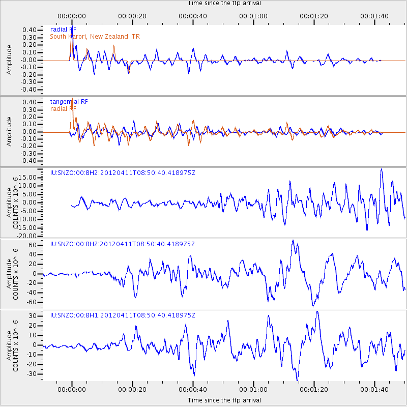
Earthquake location: Off W Coast Of Northern Sumatra
Earthquake latitude/longitude: 2.3/93.1
Earthquake time(UTC): 2012/04/11 (102) 08:38:36 GMT
Earthquake Depth: 20 km
Earthquake Magnitude: 7.4 MB, 8.5 MS, 8.6 MW, 8.6 MW
Earthquake Catalog/Contributor: WHDF/NEIC
Network: IU Global Seismograph Network (GSN - IRIS/USGS)
Station: SNZO South Karori, New Zealand
Lat/Lon: 41.31 S/174.70 E
Elevation: 120 m
Distance: 85.2 deg
Az: 131.589 deg
Baz: 277.258 deg
Ray Param: 0.044885825
Estimated Moho Depth: 15.25 km
Estimated Crust Vp/Vs: 1.64
Assumed Crust Vp: 6.461 km/s
Estimated Crust Vs: 3.94 km/s
Estimated Crust Poisson's Ratio: 0.20
Radial Match: 92.456474 %
Radial Bump: 400
Transverse Match: 86.75632 %
Transverse Bump: 400
SOD ConfigId: 558545
Insert Time: 2013-09-19 15:17:27.405 +0000
GWidth: 2.5
Max Bumps: 400
Tol: 0.001

Signal To Noise

ChannelStoNSTALTA
IU:SNZO:00:BHZ:20120411T08:50:40.418975Z2.52155613.279089E-61.3004228E-6
IU:SNZO:00:BH1:20120411T08:50:40.418975Z1.85779441.9495976E-61.0494152E-6
IU:SNZO:00:BH2:20120411T08:50:40.418975Z0.456504827.6347703E-71.6724401E-6
Arrivals
Ps1.6 SECOND
PpPs6.1 SECOND
PsPs/PpSs7.6 SECOND