You are here: Home > Network List > IU - Global Seismograph Network (GSN - IRIS/USGS) Stations List
> Station GUMO Guam, Mariana Islands > Earthquake Result Viewer
GUMO Guam, Mariana Islands - Earthquake Result Viewer
| Earthquake location: |
North Indian Ocean |
| Earthquake latitude/longitude: |
1.3/91.7 |
| Earthquake time(UTC): |
2012/04/11 (102) 08:55:46 GMT |
| Earthquake Depth: |
10 km |
| Earthquake Magnitude: |
5.8 MB |
| Earthquake Catalog/Contributor: |
WHDF/NEIC |
|
| Network: |
IU Global Seismograph Network (GSN - IRIS/USGS) |
| Station: |
GUMO Guam, Mariana Islands |
| Lat/Lon: |
13.59 N/144.87 E |
| Elevation: |
170 m |
|
| Distance: |
53.9 deg |
| Az: |
74.168 deg |
| Baz: |
261.56 deg |
| Ray Param: |
0.0657596 |
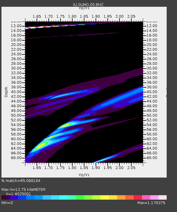
| Estimated Moho Depth: |
12.75 km |
| Estimated Crust Vp/Vs: |
1.60 |
| Assumed Crust Vp: |
4.802 km/s |
| Estimated Crust Vs: |
2.997 km/s |
| Estimated Crust Poisson's Ratio: |
0.18 |
|
| Radial Match: |
95.068184 % |
| Radial Bump: |
330 |
| Transverse Match: |
35.461945 % |
| Transverse Bump: |
227 |
| SOD ConfigId: |
558545 |
| Insert Time: |
2013-09-19 15:18:38.780 +0000 |
| GWidth: |
2.5 |
| Max Bumps: |
400 |
| Tol: |
0.001 |
|
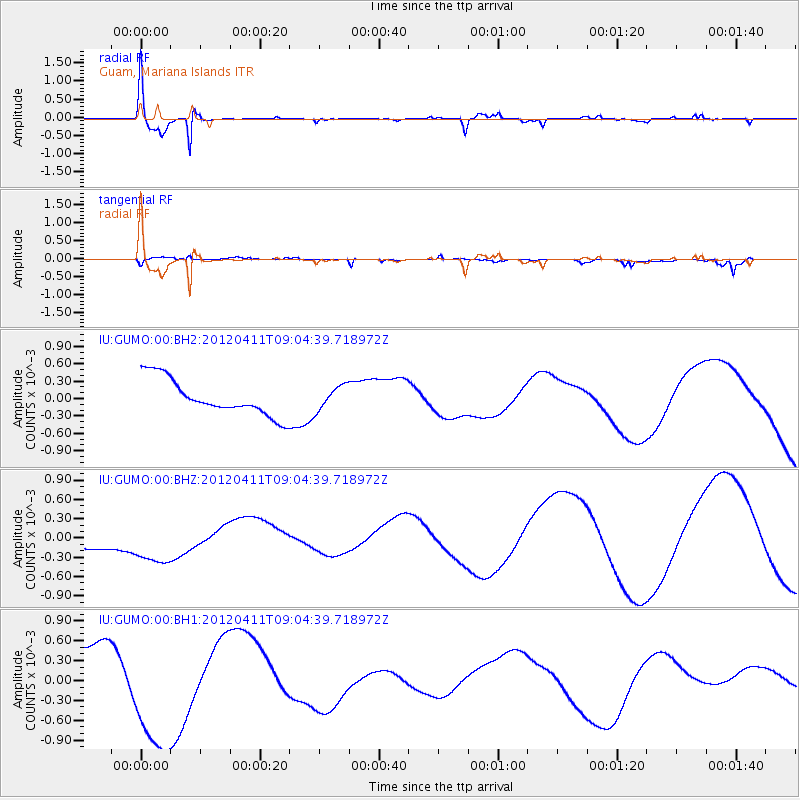
Signal To Noise
| Channel | StoN | STA | LTA |
| IU:GUMO:00:BHZ:20120411T09:04:39.718972Z | 2.0369503 | 4.67289E-4 | 2.2940619E-4 |
| IU:GUMO:00:BH1:20120411T09:04:39.718972Z | 2.990375 | 9.6447143E-4 | 3.2252524E-4 |
| IU:GUMO:00:BH2:20120411T09:04:39.718972Z | 0.6655698 | 2.0837133E-4 | 3.1307212E-4 |
| Arrivals |
| Ps | 1.7 SECOND |
| PpPs | 6.7 SECOND |
| PsPs/PpSs | 8.3 SECOND |


