You are here: Home > Network List > US - United States National Seismic Network Stations List
> Station DUG Dugway, Tooele County, Utah, USA > Earthquake Result Viewer
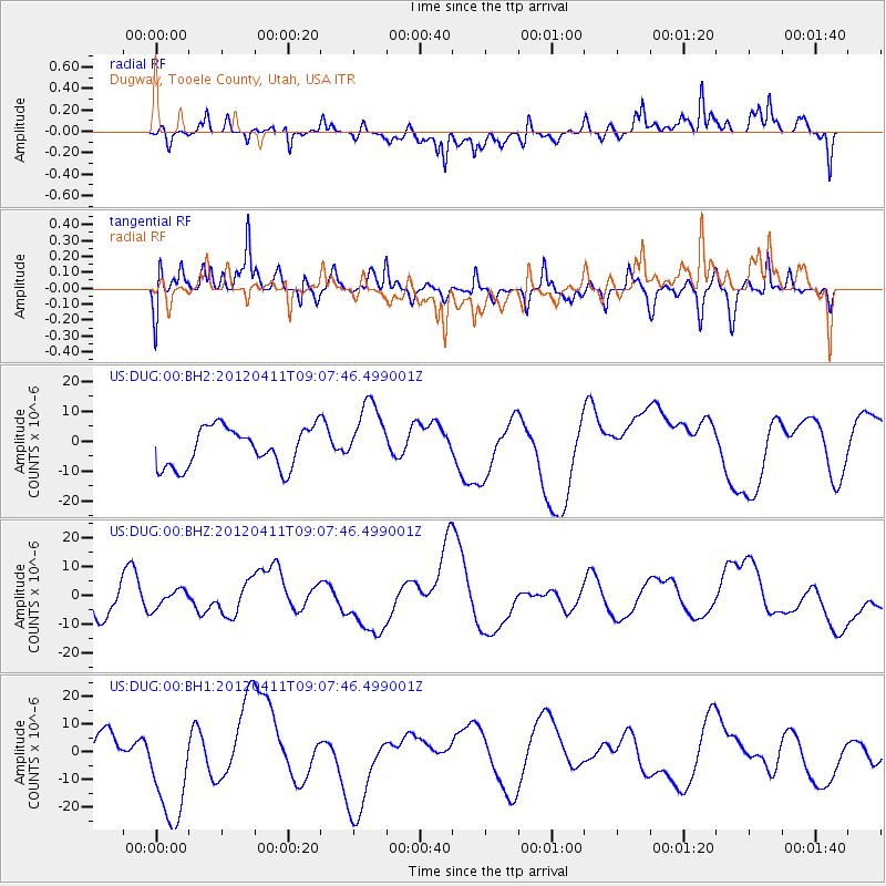
DUG Dugway, Tooele County, Utah, USA - Earthquake Result Viewer
*The percent match for this event was below the threshold and hence no stack was calculated.
| Earthquake location: |
Andreanof Islands, Aleutian Is. |
| Earthquake latitude/longitude: |
51.4/-176.1 |
| Earthquake time(UTC): |
2012/04/11 (102) 09:00:09 GMT |
| Earthquake Depth: |
21 km |
| Earthquake Magnitude: |
5.5 MB, 5.4 ML |
| Earthquake Catalog/Contributor: |
WHDF/NEIC |
|
| Network: |
US United States National Seismic Network |
| Station: |
DUG Dugway, Tooele County, Utah, USA |
| Lat/Lon: |
40.19 N/112.81 W |
| Elevation: |
1477 m |
|
| Distance: |
44.2 deg |
| Az: |
78.86 deg |
| Baz: |
306.579 deg |
| Ray Param: |
$rayparam |
*The percent match for this event was below the threshold and hence was not used in the summary stack. |
|
| Radial Match: |
45.7987 % |
| Radial Bump: |
400 |
| Transverse Match: |
43.904854 % |
| Transverse Bump: |
400 |
| SOD ConfigId: |
558545 |
| Insert Time: |
2013-09-19 15:22:31.121 +0000 |
| GWidth: |
2.5 |
| Max Bumps: |
400 |
| Tol: |
0.001 |
|
Signal To Noise
| Channel | StoN | STA | LTA |
| US:DUG:00:BHZ:20120411T09:07:46.499001Z | 0.40345412 | 3.1969892E-6 | 7.924046E-6 |
| US:DUG:00:BH1:20120411T09:07:46.499001Z | 3.1709938 | 2.0573216E-5 | 6.4879396E-6 |
| US:DUG:00:BH2:20120411T09:07:46.499001Z | 1.6867571 | 1.1114464E-5 | 6.58925E-6 |
| Arrivals |
| Ps | |
| PpPs | |
| PsPs/PpSs | |


