You are here: Home > Network List > IU - Global Seismograph Network (GSN - IRIS/USGS) Stations List
> Station MAJO Matsushiro, Japan > Earthquake Result Viewer
MAJO Matsushiro, Japan - Earthquake Result Viewer
| Earthquake location: |
Off W Coast Of Northern Sumatra |
| Earthquake latitude/longitude: |
0.8/92.5 |
| Earthquake time(UTC): |
2012/04/11 (102) 10:43:10 GMT |
| Earthquake Depth: |
25 km |
| Earthquake Magnitude: |
7.2 MB, 8.2 MW, 8.2 MW |
| Earthquake Catalog/Contributor: |
WHDF/NEIC |
|
| Network: |
IU Global Seismograph Network (GSN - IRIS/USGS) |
| Station: |
MAJO Matsushiro, Japan |
| Lat/Lon: |
36.55 N/138.20 E |
| Elevation: |
405 m |
|
| Distance: |
55.2 deg |
| Az: |
44.592 deg |
| Baz: |
240.659 deg |
| Ray Param: |
0.06488761 |
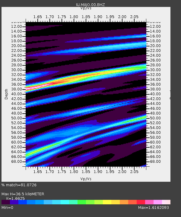
| Estimated Moho Depth: |
36.5 km |
| Estimated Crust Vp/Vs: |
1.66 |
| Assumed Crust Vp: |
6.461 km/s |
| Estimated Crust Vs: |
3.887 km/s |
| Estimated Crust Poisson's Ratio: |
0.22 |
|
| Radial Match: |
91.8726 % |
| Radial Bump: |
400 |
| Transverse Match: |
73.162415 % |
| Transverse Bump: |
400 |
| SOD ConfigId: |
558545 |
| Insert Time: |
2013-09-19 15:28:04.416 +0000 |
| GWidth: |
2.5 |
| Max Bumps: |
400 |
| Tol: |
0.001 |
|

Signal To Noise
| Channel | StoN | STA | LTA |
| IU:MAJO:00:BHZ:20120411T10:52:10.818994Z | 1.4539357 | 1.4821869E-5 | 1.0194308E-5 |
| IU:MAJO:00:BH1:20120411T10:52:10.818994Z | 0.769221 | 8.999697E-6 | 1.1699754E-5 |
| IU:MAJO:00:BH2:20120411T10:52:10.818994Z | 0.8678862 | 8.773306E-6 | 1.0108821E-5 |
| Arrivals |
| Ps | 4.0 SECOND |
| PpPs | 14 SECOND |
| PsPs/PpSs | 18 SECOND |


