You are here: Home > Network List > IU - Global Seismograph Network (GSN - IRIS/USGS) Stations List
> Station HNR Honiara, Solomon Islands > Earthquake Result Viewer
HNR Honiara, Solomon Islands - Earthquake Result Viewer
*The percent match for this event was below the threshold and hence no stack was calculated.
| Earthquake location: |
Off W Coast Of Northern Sumatra |
| Earthquake latitude/longitude: |
1.2/92.1 |
| Earthquake time(UTC): |
2012/04/11 (102) 19:04:20 GMT |
| Earthquake Depth: |
14 km |
| Earthquake Magnitude: |
5.5 MB |
| Earthquake Catalog/Contributor: |
NEIC PDE/NEIC PDE-M |
|
| Network: |
IU Global Seismograph Network (GSN - IRIS/USGS) |
| Station: |
HNR Honiara, Solomon Islands |
| Lat/Lon: |
9.44 S/159.95 E |
| Elevation: |
100 m |
|
| Distance: |
68.4 deg |
| Az: |
100.572 deg |
| Baz: |
275.045 deg |
| Ray Param: |
$rayparam |
*The percent match for this event was below the threshold and hence was not used in the summary stack. |
|
| Radial Match: |
64.509514 % |
| Radial Bump: |
400 |
| Transverse Match: |
68.69119 % |
| Transverse Bump: |
400 |
| SOD ConfigId: |
558545 |
| Insert Time: |
2013-09-19 15:32:43.675 +0000 |
| GWidth: |
2.5 |
| Max Bumps: |
400 |
| Tol: |
0.001 |
|
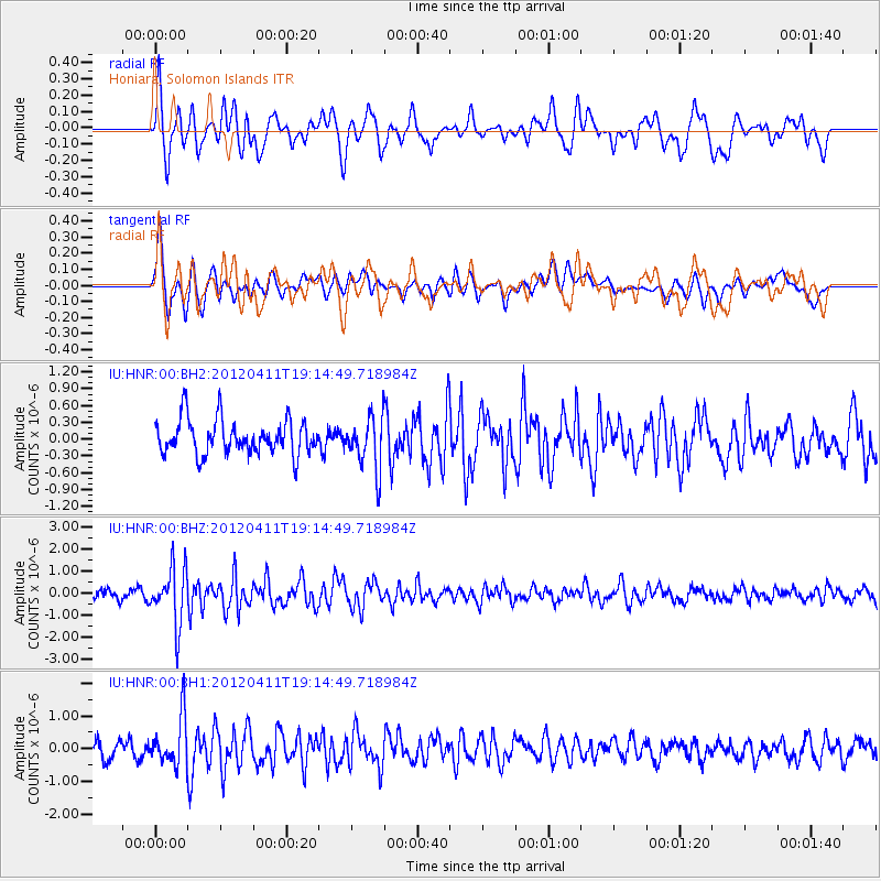
Signal To Noise
| Channel | StoN | STA | LTA |
| IU:HNR:00:BHZ:20120411T19:14:49.718984Z | 6.4296594 | 1.294776E-6 | 2.0137551E-7 |
| IU:HNR:00:BH1:20120411T19:14:49.718984Z | 2.2543302 | 7.2527104E-7 | 3.217235E-7 |
| IU:HNR:00:BH2:20120411T19:14:49.718984Z | 1.4668555 | 4.5005785E-7 | 3.0681812E-7 |
| Arrivals |
| Ps | |
| PpPs | |
| PsPs/PpSs | |


