You are here: Home > Network List > IU - Global Seismograph Network (GSN - IRIS/USGS) Stations List
> Station PMG Port Moresby, New Guinea > Earthquake Result Viewer
PMG Port Moresby, New Guinea - Earthquake Result Viewer
*The percent match for this event was below the threshold and hence no stack was calculated.
| Earthquake location: |
Off W Coast Of Northern Sumatra |
| Earthquake latitude/longitude: |
1.2/92.1 |
| Earthquake time(UTC): |
2012/04/11 (102) 19:04:20 GMT |
| Earthquake Depth: |
14 km |
| Earthquake Magnitude: |
5.5 MB |
| Earthquake Catalog/Contributor: |
NEIC PDE/NEIC PDE-M |
|
| Network: |
IU Global Seismograph Network (GSN - IRIS/USGS) |
| Station: |
PMG Port Moresby, New Guinea |
| Lat/Lon: |
9.40 S/147.16 E |
| Elevation: |
90 m |
|
| Distance: |
55.8 deg |
| Az: |
102.136 deg |
| Baz: |
277.87 deg |
| Ray Param: |
$rayparam |
*The percent match for this event was below the threshold and hence was not used in the summary stack. |
|
| Radial Match: |
70.35471 % |
| Radial Bump: |
386 |
| Transverse Match: |
56.45672 % |
| Transverse Bump: |
400 |
| SOD ConfigId: |
558545 |
| Insert Time: |
2013-09-19 15:33:14.673 +0000 |
| GWidth: |
2.5 |
| Max Bumps: |
400 |
| Tol: |
0.001 |
|
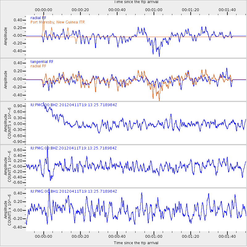
Signal To Noise
| Channel | StoN | STA | LTA |
| IU:PMG:00:BHZ:20120411T19:13:25.718984Z | 2.2861292 | 3.2320665E-7 | 1.4137724E-7 |
| IU:PMG:00:BH1:20120411T19:13:25.718984Z | 1.3428909 | 2.4065017E-7 | 1.7920307E-7 |
| IU:PMG:00:BH2:20120411T19:13:25.718984Z | 1.1375889 | 3.8363513E-7 | 3.372353E-7 |
| Arrivals |
| Ps | |
| PpPs | |
| PsPs/PpSs | |


